(Upload on March 6 2022) [ 日本語 | English ]
Mount Usu / Sarobetsu post-mined peatland
From left: Crater basin in 1986 and 2006. Cottongrass / Daylily
HOME > Lecture catalog / Research summary > Wetland Research > Glossary > Wetland
Definitions (various):
[wetlands defined by Ramsar Convention] Five major types of wetlands (湿原型)

(Leck 1989) Vegetation classificationObligate (OBL)Facultative wetland (FACW) 2/3 + Facultative (FAC) Facultative upland (FACU)__1/3 - Upland (UPL) |
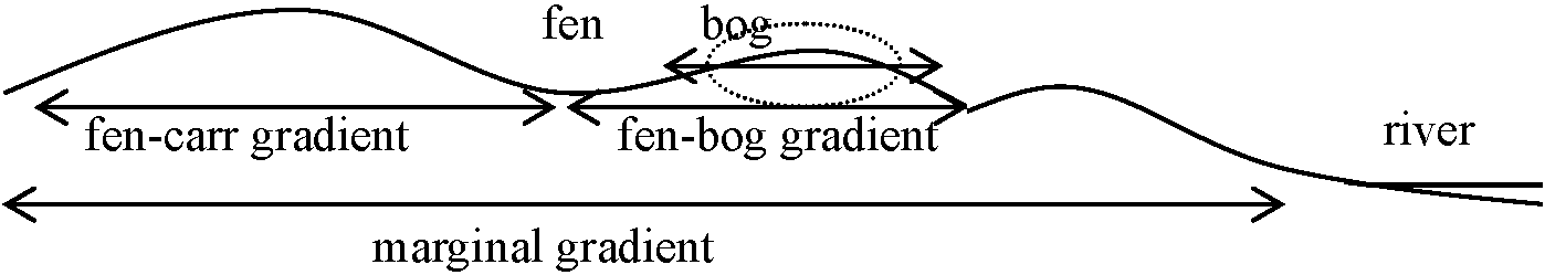
Type [ bog | fen | marsh | swamp | open water ] [ tussock ] Hydrology: continued saturation > 1 wk during the growing season Environmental gradientFour types of gradients
Environmental factor: pH, DO, conductivity (important factor) + temperature, ignition loss |
|
Very acid conditions with limited woody growth, dominated by Sphagnum; conditions may be dry to plants because the peat mat prevents roots from reaching water; they root in the peat and get nutrients from rainwater. Typical associations in Washington State: Sphagnum/Vaccinium oxycoccos; Ledum groenlandicum/Sphagnum; Sphagnum-Carex spp. Types of Bogs • Open bogs are comprised mostly of sphagnum moss and sparse sedges • Shrubby bogs support low-lying shrubs, bog cranberry, and blueberries • Treed bogs are identified by stunted black spruce with a moss and shrub understory Benefits and Functions • Peatlands store carbon and reduce the effects of global warming • Help prevent downstream flooding by absorbing precipitation • Support plants commonly used by people, including cranberries,blueberries, and Labrador tea |
Topographical classificationraised bog, basin, string, continental, island, palsa, maritime, bowl, shinkhole, floating, shore, flat, polygonal, peat plateau, peat moundRaised bog (隆起高層湿原, Regenmoore or Hochmoore in German)≈ ombrotrophic bogacidic, wet habitats with poor mineral salts Plants represented by peat moss +
Woody vegetation Muskeg (マスケグ): large expanse of peatlands or bogs (used in Canada and Alaska) Pakihi (パキヒ): peatland in southwestern New Zealand dominated by sedges, rushes, ferns, and scattered shrubs. Most pakihi form on terraces or plains of glacial or fluvial outwash origin and are acid and exceedingly infertile Utasai bog (歌才湿原)Sphagnum-dominated bog in Kuromatsunai TownThelypteris confluens establishes in disturbed area (Tsuyuzaki & Zhang 2020) ☛ flora |
|
A fen is a peatland influenced by flowing surface water and/or discharged groundwater. The water moving through fens comes in contact with mineral soil creating a more nutrient rich environment than bogs. Fens vary in wetness and species diversity, with wetter fens being richer. Types of Fens • Gramnoid fens are dominated by sedges and are usually the wettest • Shrubby fens contain stunted shrubs such as bog birch and willows interspersed with sedges and buckbean • Treed fens are much drier and contain stunted trees, especially tamarack and sometimes black spruce Benefits and Functions • Fens move water and nutrients through the landscape • Sustain water levels and connectivity of wetlands across the landscape |
• As peatlands, fens store carbon and reduce the effects of global warming • Help prevent downstream flooding by absorbing precipitation, and excess water from adjacent uplands Topographical classificationstring (ストリング), seepage (浸透水性), net (網状), floating (浮島) → floating fen (根無し湿原), draw (谷地), horizontal (平坦), pond (池溏), collapse (崩落), palsa (パルサ), spring (湧水), slope (斜面) → sloping fen (斜面/傾斜地湿地)Heath (ヒース)shrubland dominated by ericaceous species, such as Andromeda, Bruckenthalia, Calluna, Erica, Daboecia
often developed on free-draining infertile, acidic soils Makunbetsu fen or swamp (マクンベツ湿原)adjacent to Ishikari River in Bannaguro, Ishikari City (closed in winter)Large Lysichiton camtschatcensis communities in early spring |
|
Marshes are often a transition zone between open water and shorelines of lakes and river systems. They are shallow wetlands with water levels that fluctuate seasonally. Marshes receive water from precipitation, groundwater, and stream inflow. Types of Marshes • Freshwater marshes are very productive and a variety of plants thrive on the high nutrient levels
Tidal freshwater marsh: marsh along rivers and estuaries close enough to the coastline to experience significant tides by nonsaline water. Vegetation is often similar to nontidal freshwater marshes |
• Salt marsh (saltwater marsh) (塩湿地) are normally associated with coastlines and fewer plants can tolerate the saline conditions Benefits and Functions • Plants filter and trap pollutants from the water • Great place for wildlife viewing • Provides food and shelter for many different species of birds and mammals • Moderates flooding and erosion by slowing down water flow • Provide habitat for wildlife species important for trapping, such as muskrat Pothole (ポットホール): shallow marsh like pond, particularly as found in the Dakota sand central Canadian provinces, the so-called prairie pothole region Playa (プラヤ): an arid-to semiarid-region wetland that has distinct wet and dry seasons (southwest US for marsh like ponds similar to potholes, but with a different geologic origin) Raupo swamp: cattail (Typha) marsh in New Zealand Reedmace swamp: Typha marsh in UK |
Swamps are often a transition between upland forest and other wetland types. They are normally associated with river floodplains, lakes, and ponds. Swamps are typically dominated by tall trees and shrubs, with densities greater than 60%. They can occur in either mineral or organic soil.Types of Swamps• Thicket swamps are characterized by tall shrubs, like willow• Coniferous swamps are dominated by white or black spruce • Hardwood swamps feature balsam poplar and white birch Benefits and Functions• Moderate floods by slowing water flow• Fertile soils support a diversity of trees, shrubs, and other plants • Snags, standing dead trees, provide homes for cavity-nesting species like goldeneye, American kestrel, and northern flicker • Recycle nutrients from decaying plant matter • Vegetation protects shoreline areas from erosion and sedimentation Carr (カール): forested wetlands characterized by Alnus and Salix (Europe) |
Riparian forest (河畔林)≈ riparian woodlandAreas that are affected by rivers (+ various water bodies, such as stream, pond and lake), often subjected to inundation transition zones between an upland terrestrial environment and an aquatic environment Gallery forest= fringing foresta corridor along rivers or wetlands, projecting into landscapes that are otherwise only sparsely treed such as savannas, grasslands or deserts Ex. Llanos ecoregion (Venezuela and Colombia), Cerrado Region (tropical savanna in Brazil), Madagascar and Konza Prairie (Kansas) Oxbow: abandoned river channel, often developing into a swamp or marshPocosin (ポコシン): peat-accumulating, non riparian freshwater wetland, generally dominated by evergreen shrubs and trees and found on the southeastern Coastal Plain of the US. The term comes from the Algonquin for "swamp on a hill" |
| Shallow water is distinct wetlands that represent a transition from marshes to deeper aquatic ecosystems such as lakes or rivers. They include shallow lakes and ponds, as well as wetlands found beside rivers, coastlines and shorelines. |
Benefits and Functions • Provides conditions for dense submergent vegetation • Habitat for a variety of aquatic insects and fish • Provides food for many different birds • Can recharge groundwater supplies Lagoon (ラグーン): a deep water enclosed or partially opened aquatic system, especially in coastal delta regions (frequenctly used in Eurrope) Dambo (ダンボ): a shallow tree-less wetland in which water collects in the rainy season (used in southern Africa) |
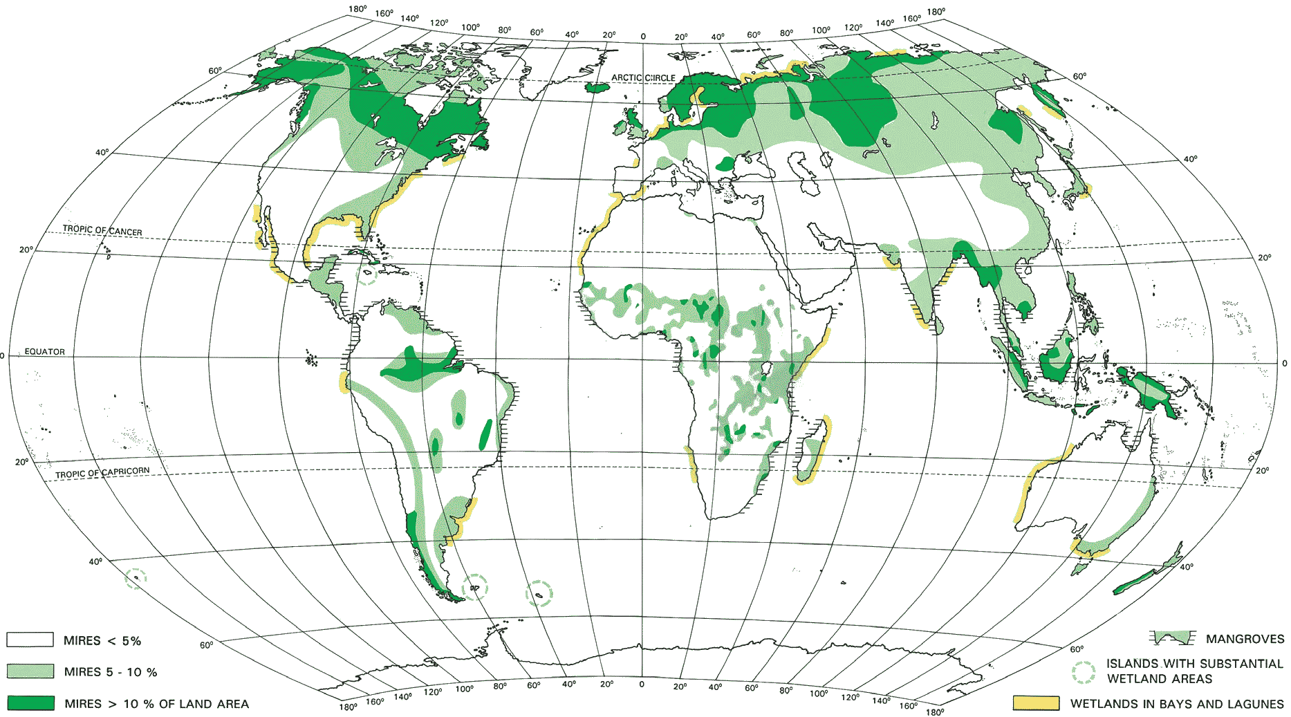
Distribution of mires. Extent and location of global mires and peatlands (Lappalainen 1996)
| Region | Area | Type/location | |
| A. North America | 1. Canada and Alaska | Tundra Boreal forest Hudson Bay lowlands Complex montane, riverine, coastal systems in Alaska Prairie potholes in Canada | |
| 2. USA | East coast estuaries Florida sawgrass marsh Mississippi River delta Potholes and playas California internally drained systems Western riparian systems Pacific coast estuaries |
||
| B. Mexico, Central America, Caribbean | 1. Mexico | Main wetlands on coast | |
| 2. Caribbean | Most extensive wetlands on larger islands Islands with +1000 m mountains create rivers Much converted to rice farming |
||
| 3. Central America | Complex systems on Caribbean side (70% of precip) Mangroves on Pacific side (30% of precip) Much conversion to shrimp mariculture |
||
| C. South America | 1. Northern South America | Amazon basin Maranhao and rivers in east Brasil Llanos of Orinoco drainage |
|
| 2. Southern South America | Flooded Pantanal feeds Paraguay River Parana River runs south to join Paraguay River Puna: Andean altiplano above 10,000 |
||
| D. Europe | 1. Fennoscandia, UK, N. Russia | Ice and precipitation dominated systems Palsa-, blanket-, aapa-, raised-, polygon bogs (mires) |
|
| 2. Coastal shallows | Wadden Sea | ||
| 3. Floodplain systems | Loire, Rhine, Vistula, Danube, Dnieper, Dniester, Volga | ||
| 4. Mediterranean basin | Mostly deltas: Rhone, Po, Nile | ||
| E. Middle East | 1. Tigris and Euphrates | Fed by rivers from mountains of Turkey, Iran, Afghanistan | |
| 2. Inland drainage systems like Dead Sea | |||
| 3. Mangroves on coasts of Red Sea, Indian Ocean, Persian Gulf | |||
| F. Africa | 1. East Africa and the Nile Basin | Great Rift Valley Lake Victoria Valley of the Nile Sudd floodplain |
|
| 2. West and Central Africa | Floodplains of the Senegal, Nile, Lake Chad; in arid Sahel Zaire River system Zaire and Congo Rivers; year-round flooding |
||
| 3. Southern Africa | Zambesi River system Okavanga Delta (N. of the Kalahari Desert) Etosha Pan in Angola |
||
| G. Asia | 1. Northern Asia | Ob-Irtysh basin High mountains of N. Central Asia (Lake Baikal) Tundra in the North Internally drained seas: Caspian, Aral (eco-disaster) |
|
| 2. Central and South Asia | Himalayan range dominates; generates water for: Indus, Ganges, Brahmaputra, Irrawaddy, Mekong, Yangtze, Yellow Rivers Extensive floodplain and delta cultures Monsoon wetlands of Bangladesh (Ganges delta) Sundarbans (mangroves, Bengal tigers) |
||
| 3. East Asia | High altitude lake and bog systems, Tibetan and Mongolian plateaus Yangtze and Yellow River floodplains Estuarine and mangrove systems on China coast Korea: western and southern estuaries Japan: most remaining wetlands on Hokkaido |
||
| H. Southeast Asia | 1. Equatorial | Very wet, naturally forested, high diversity forests Mangrove, swamp forest |
|
| 2. Long coastline, shallow lagoons, coral reefs | |||
| I. Australia | 1. Mostly flat and arid | ||
| 2. Great Dividing Range along east coast | Generates much hydrology; monsoons approach from east Well-watered river valleys and estuaries to the east Darling and Murray floodplains to the interior |
||
| 3. Ephemeral internally-drained systems in interior | Dry climate with widely spaced wet episodes Salt lakes |
||
| 4. Estuaries and floodplains in the tropical north | |||
| J. New Zealand & Pacific Islands | 1. New Zealand: maritime climate and much rain | South Island has diverse wetland landscape Bogs, floodplains, podocarp swamp forests North Island has estuaries |
|
| 2. Pacific islands Mostly small islands with salt or brackish systems | Lagoons, mangroves, brackish lakes Larger islands with mountains create river systems Freshwater lakes form in volcanic calderas |
|
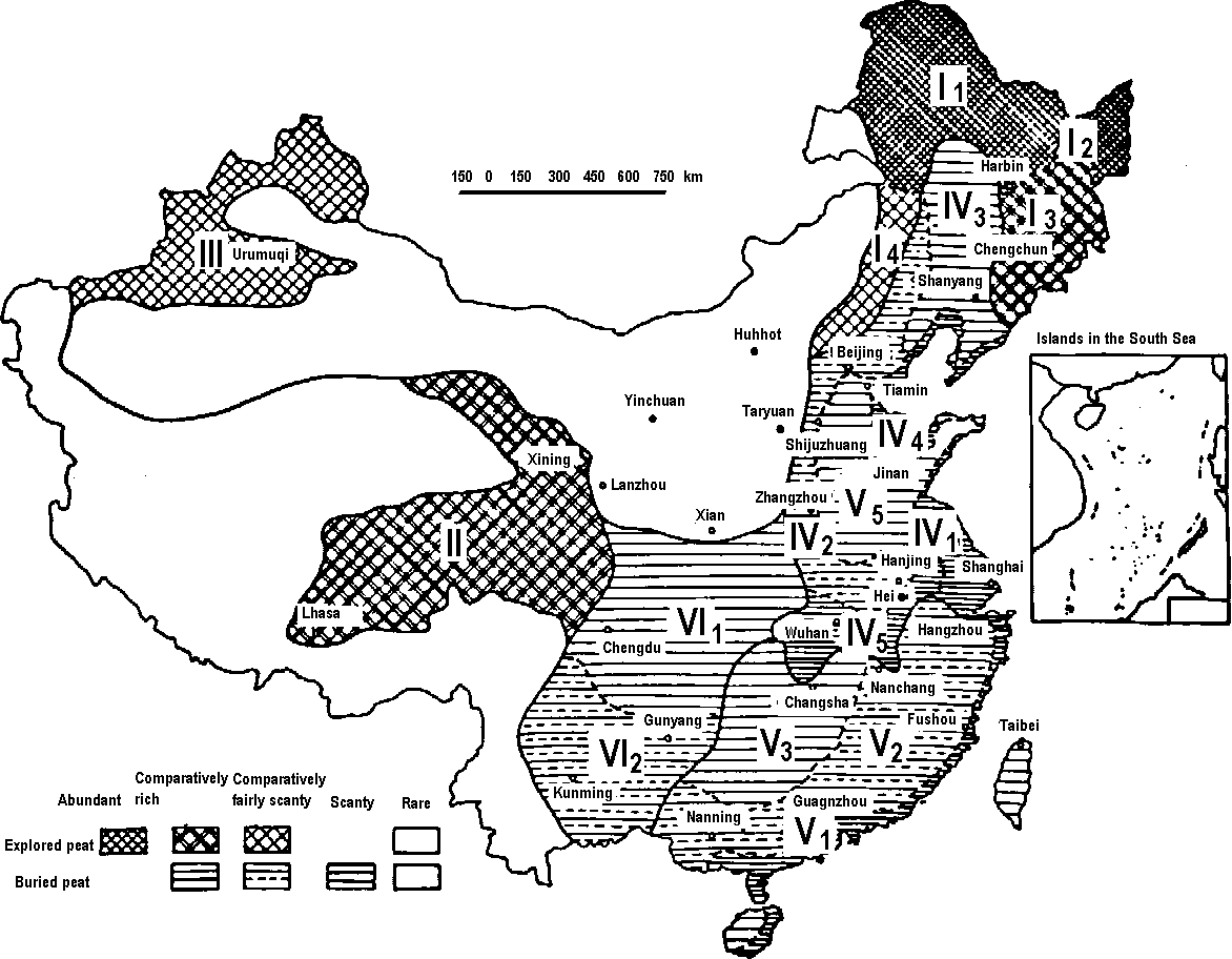
Fig. 1. Peat distribution in China (中国の泥炭分布)
I: Peat distribution region of north-eastern mountain land, hills and depressions II: Peat distribution region of the mountain plateaus and valley basins in Omg-zang plateau III: Peat distribution region of north-western lofty mountains and peadmonts IV: Buried peat distribution region of eastern deposit plateau V: The buried peat distribution region of low mountains, hills and coast in the middle and southern parts of China VI: The buried peat distribution region of south-western mountain plateaus and basins Table 2. The area of peatlands and amount of peat deposit in the respective regions I to VI. The values are determined by references and field measurements. The area is defined as peat > 0.3 m in depth. The amount is expressed by dry weight.
Region Area (× 10M4 ha)            Amount (× 109 ton)
       -------------------------- -------------------------
       Suface-  Deposited- Total  Surface- Deposited- Total
       peatland peatland           peatland peatland
  I      214.0     3.1     217.1   153.2      2.5     155.7
  II      94.0     -        94.0    51.0      -        51.0
  III     36.0     1.5      37.5    11.3      0.5      11.8
  IV       0.9    38.0      38.9     0.5     29.8      30.3
  V        0.7     9.2       9.9     0.3      6.5       6.8
  VI       2.1    16.4      18.5     1.2     13.4      14.6
  Total  347.7    68.2     415.9   217.5     52.7     270.2
• wetland research in China (中国での湿原研究) |
Table 3. Main ecological properties of mires in China.
| Ecological properties | Microtopography (grassy marshland) | Hydrologic condition | Plant community | Peat layer | |||||
| Types of peatmire | Form | Height (m) | Desnity (%) | Phreatic surface (m) | Water-logged depth (m) | Thickness (m) | Water content (%) | pH | |
| Permanently water- logged peatmire in depression | Floating blanket | - | - | - | 0.1-0.4 | Carex lasiocarpa Menyanthes triflora Glyceria aquatica Utricularia vulgaris | 3-6 | > 90 | 7.0-7.5 |
| Seasonally water- logged peatmire in scattered hills | Ridge | 0.3-0.6 | 5-15 | 0.0.-0.05 | 0.05-0.1 | Carex muliensis Equisetum heleocharis Helecharis sp. | 2-4 | 80 | 7.0-7.8 |
| Seasonally water- logged peatmire on hills | Network | 0.3-0.5 0.2-0.7 | 30-50 > 50 | < 0.1 | 0.05-0.15 | Carex spp. Kobresia tibetica Kobresia spp. | 1-3 | 70-80 | 7.0-8.0 |
| Temporarily water- logged peatmire in scattered hills | Lump | 0.2-0.3 | 10-30 | 0.1-0.4 | 0.0-0.1 | Kobresia spp. Carex spp. | 0.3-1 | < 70 | 7.0 |
| Type | Types of peat | Decompo- sition (%) | Total C (%) | Organic matter (%) | Raw ash (%) | HCl-soluble matter (%) | Total N (%) | P2O5 (%) | K2O (%) | CaO (%) | Fe2O3 (%) | Total humic acid (%) | ph (H2O) |
| Low-moor peat | Carex | 25.8 | 42.3 | 72.9 | 21.1 | 7.9 | 2.1 | 0.24 | 0.25 | 1.21 | 1.86 | 36.0 | 5.3 |
| Carex-reed | 30.1 | 40.1 | 69.2 | 30.8 | 9.1 | 2.2 | 0.26 | 0.23 | 1.54 | 2.65 | 36.8 | 6.4 | |
| Carex | 28.7 | 35.3 | 60.9 | 39.1 | 8.8 | 2.0 | 0.05 | 0.21 | 5.12 | 7.51 | 33.6 | 7.8 | |
| Aniphyllum fortunei-Carex | 24.2 | 42,0 | 72.5 | 27.6 | 8.9 | 1.6 | 0.26 | 0.24 | 0.90 | 2.47 | 26.8 | 5.9 | |
| Carex | 48.7 | 35.1 | 60.7 | 39.3 | 7.5 | 0.9 | 0.13 | 0.09 | 1.00 | 1.69 | 35.7 | 6.2 | |
| Ligneous | 50.1 | 41.4 | 71.3 | 28.7 | 7.1 | 0.6 | 0.06 | 0.07 | 0.20 | 0.56 | 50.5 | 5.6 | |
| Carex | 51.3 | 17.5 | 30.1 | 69.2 | 10.2 | 1.7 | 0.23 | 0.34 | 1.40 | 2.08 | 11.6 | 5.8 | |
| High-moor peat | Ledum palustre-moss peat | 17.5 | 51.4 | 88.7 | 11.4 | 4.4 | 1.4 | 0.15 | 0.14 | 0.78 | 1.24 | 23.1 | 4.3 |
| Moss peat | 16.1 | 50.8 | 87.5 | 12.5 | 3.7 | 0.9 | 0.21 | 0.15 | 0.61 | 1.03 | 19.7 | 4,2 | |
| Carex moss peat | 19.2 | 40.7 | 70.2 | 29.9 | 7.7 | 1.5 | 0.20 | 0.22 | 1.01 | 2.70 | 32.8 | 5.0 | |
| Medium-moor peat | Larix-Carex moss peat | 18.3 | 35.7 | 71.2 | 38.9 | 6.5 | 1.4 | 0.29 | 0.20 | 0.77 | 1.85 | 30.0 | 4.7 |
Wetland vegetationThe US Fish & Wildlife Service has a comprehensive classification system useful for wetlands.Coastal vegetationThe environment of coastal estuaries (Estuarine system), including river deltas, and bays is dominated by tidal fluctuations. This factor and its correlates, such as fluctuating salinity,poor aeration, wave action, and twice daily cycles of submergence and exposure, produce vegetation types characterized by relatively few species. Coastal marshes are highly productive.Mudflats:Low intertidal to subtidal muds, dominated by Zostera marina. Typical association: Zostera marinaLow salt marsh:Higher intertidal, usually with some fresh water influence, especially in river deltas. Inundated nearly every day. Typical associations: Scirpus maritimum; Carex lyngbey; Calydistichlis spicata; Jaumea carnosa-Disp; Disp-Salicornia virginica; Savi. |
High salt marsh:Upper marshes, where daily inundation is less than a daily occurrence. Typical associations: Agrostis alba-Festuca rubra; Agal-Carex lyngbyei; Caly-Distichlis spicata; Disp-Salicornia virginica; Potentilla pacifica-graminoids.Table. Common species in a vertical gradient.
Species Eelgrass Low marsh High marsh
    Zostera marina            X
    Salicornia virginica      t          X            x
    Triglochin maritimum      t          X            x
    Carex lyngbeyi                       X            x
    Jaumea carnosa                       X            x
    Spergularia marina                   X            x
    Scirpus americanus                   X            x
    Cotula coronopifolia                 X            x
    Cuscuta salina                       X            t
    Spartina alterniflora                X            t
    Atriplex patula                      x            X
    Plantago maritima                    x            X
    Distichlis spicata                   x            X
    Scirpus maritimum                    t            X
    Deschampsia caespitosa                            X
    Hordeum brachyanthermum                           X
    Grindelia integrifolia                            X
    Potentilla pacifica                               X
    Trifolium wormskjoldii                            X
    Agrostis alba                                     X
    Festuca rubura                                    X
|
|
Inland wetland vegetation is generally associated with rivers (riparian), lakes (lacustrine), or other wetlands not directly influenced by lakes or rivers (palustrine). Riverine vegetation is usually unstable and dominated by elements of the forested wetlands described below. Freshwater marshUsually associated with lakes (lacustine), or areas of limited drainage (palustrine).Typical Lacustrine Associations: Deep: Nuphar-Nymphaea; Scirpus acutus; Shallow: Typha latifolia; Phalaris arundinacea; Phragmites communis; Tyla-Lythrum salicaria; Carex obnupta (plus various graminoids-dominated associations); Phar-Iris pseudacorus; Tyla-Scirpus microcarpus. |
(Deep marsh, Emergent wetland) Eleocharis spp. = emergentEpilobium angustifolium = emergent Iris pseudacorus = emergent Lemma minor = floating Lythrum salicaria = emergent (intro) Myriophyllum spicatum = submerged (intro) Nuphar polysepalum = floating fixed (intro) Nymphaea odorata = floating fixed (intro) Oenanthe sarmentosum = emergent Phalaris arundinacea = emergent Phragmites communis = emergent Polygonum spp. = submerged, submerged-emergent Scirpus microcarpus = emergent Typha latifolia = emergent Palustrine systems are nontidal wetlands dominated by woody vegetation or persistent emergents. They include marshes, swamps, ponds (not lakes) and bogs. They can be located shoreward of lakes and rivers, on flood plains, or in isolated catchment basins. |
|
The trail starts behind the MOHAI and traverses through several wetland associations. Characterize each association, based on the US Fish and Wildlife system (e.g., palustrine forested wetland). Species (common name), description Carex aquatilis (water sedge), leaves w/3-ranked sheaths Eleocharis spp. (spike-rush), solitary, term. spike; emergent Equisetum spp. (horsetail) Iris pseudocorus (yellow marsh iris), yellow flowers; emergent Juncus balticus (baltic rush), diffuse inflorescence Juncus effusus (common rush), stem round; many flowers, lateral, dense inflorescence Lemna minor (duckweed), floating aquatic Lythrum salicaria (purple loosestrife), red flowers, leaves like fireweed; emergent Myriophyllum spicatum (watermilfoil), feathery leaves; submerged aquatic Nuphar polysepalum (Indian pondlily), sepals = 9; flowers yellows Nymphaea odorata (American waterlily), sepals = 4; flowers white/pink Oenanthe sarmentosa (water parsley), dissected leaves Phalaris arundinacea (reed canarygrass), congested panicle; large ligules; emergent |
Potentilla pacifica (Pacific silverweed), pinnately compound leaf Rumex crispus (curly dock weed) Scripus microcarpus (small-fruited bulrush), many large, terminal spikelets; emergent Scripus pallidus (pale bulrush), few large, lateral spikelets Typha latifolia (cattail), emergent Alnus rubra (red alder), leaves with revolute margins Betula sp. (birch), white bark Cornus stolonifera (red-osier dogwood), red stem; cottony veins when pulled apart Populus trichocarpa (black cottonwood), large deltoid leaves Rhamnus purshiana (cascara), rhomboid leaf; thick veins Salix lasiandra (Pacific willow), narrow leaf, large round stipules, glands Salix hookeriana (Hooker's willow), broad, rounded leaf Salix scouleriana (Scouler's willow), butterfly stipules, broadleaf, leaves reddish beneath Spiraea douglasii (steeplebush), hardback cylindric rose-colored inflorescence |
BogWet meadowAssociated with lakes (lacustine) or wet depressions and bogs (palustrine). Several species from shallow marsh, plus various grasses, sedges, and rushes. Often border on persistent emergent wetlands
Sedge meadow: very shallow wet land dominated by several species of sedges (e.g., Carex, Scirpus and Cyperus) Scrub-shrub palustrine wetlandsAssociated with seasonally or permanently flooded low-lying terrain, usually part of a stream drainage or swamp system. It differs from forested wetlands in being dominated by shrub species or by young tree species, especially alder. Typical associations in Washington State: Spiraea douglasii; Acer circinatum/Athyrium filix-femina; Cornus stolonifera-Acci; Alnus rubra-Salix spp.; Rhamnus purshiana-Salix spp.; Salix spp.; Rubus spectabilis (seral); Rubus discolor (seral).Forested wetlandAssociated with seasonally or permanently flooded terrain, sometimes riparian or lacustrine, but often simply in poorly drained areas. Typical associations in Washington State: Fraxinus oregana/Athyrium filix-femina; Thujaplicata/ Lysichitum americanum; Alnus rubra/Acer circinatum; Populus trichocarpa-Acer macrophyllum; Populus tremuloides/Salix spp. |
Table. Representative species on bog: Species [wet meadow, scrub-shurb, forested wetland, bog]
|
|
Mangrove (= mangal) is one of the saltwater (s.l.) biomes (バイオーム) with rich fauna. Mangrove forests replace salt marsh in tropical and subtropical regions, well-known as "marine forest".
T/R ratio ≈ 1.0 (T/R in most forests = 3-4) Function• accumulation of pollutants (e.g., heavy meatals, such as Cu, Hg, Cd, Zn and Pb) derived from rivers and tidal habitats→ developing urban mangroves • reduction of flooding, including tsunami• food resources, e.g., shellfish Area15,500,000 ha in the world (1980)Asia 6,300,000 ha, Africa 3,400,000 ha, America 5,780,000 ha land use change (mostly due to human activities) |
Australiatotal area = ca 1500 km²mangals (mangrove swamp and/or forest) mainly distributed on the northern and eastern coast → Western Australia (西オーストラリア) China37 mangrove species in 25 genera and 20 familiesmostly distributed in six provinces (Zhejiang, Taiwan, Fujian, Hainan, Guangxi, and Guangdong), and two special administrative regions (Hong Kong and Macao) |
Aquatic organism (水生生物)Aquatic plant= hydrophytes and macrophytesplants adapted in aquatic environments, including saltwater and/or freshwater
submerged (沈水植物): rooted hydrophyte (固着性植物) |
Morphological classificationAmphiphytes: adapt to live either submerged or on landElodeids: stemmed, complete their lifecycle submerged, or with only their flowers above the water surface Isoetids: rosette-forming, complete their lifecycle submerged Helophytes (沼沢植物): rooted in the bottom with leaves above the water surface Nymphaeids: rooted in the bottom with leaves floating on the water surface Pleuston (浮表生物): vascular and floated freely in the water |
Tussock (谷地坊主) called in plant ecology
A clump or tuft, as of growing grass or sedge
→ earth hummock (十勝坊主)
New ZealandOn the mountainside of Mount Ruapehu, New Zealand, on December 17, 1996. In Tongariro National Park, a few types of tussocks were classified: Chionochloa rubra Zotov [Poaceae] = red tussock, Festuca novae-zelandiae [Syn. Festuca ovina var. novae-zelandiae] (and Festuca matthewsii) = hard tussock (and silver tussock), and Rytidosperma setifolium = bristle tussock.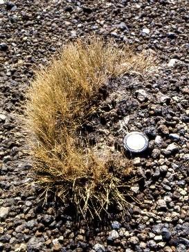
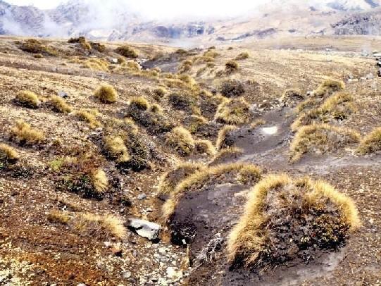
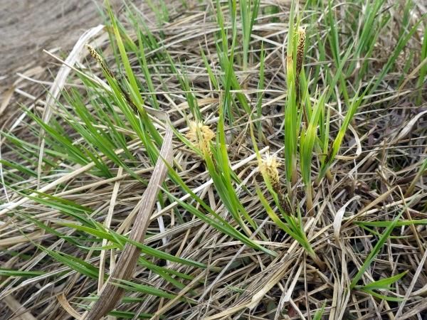
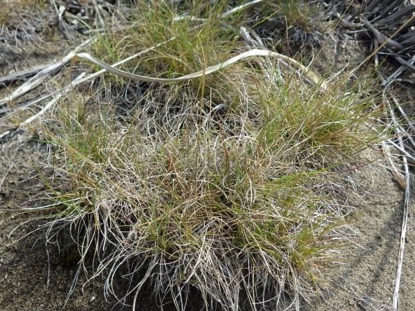
[Left] Close-up showing a single tussock in decayed stage. [Right] A conony of tussocks. You may be able to see 'facititative effects' of tussocks on cohabitants. Japan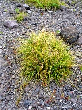
|
[Left] Carex oxyandra on Mount Usu. [Right] Carex middendorffii on a post-mined Sarobtetsu mire (Koyama & Tsuyuzaki 2010). The tussocks facilitate the establishment of seedling by altering microhabitats (Koyama & Tsuyuzaki 2012). However, the facilitative effects were eliminated when the climate was unusual (Koyama & Tsuyuzaki 2013).
Tussock formed by Festuca rubra. Basically this species establishes on dry sites. Alaska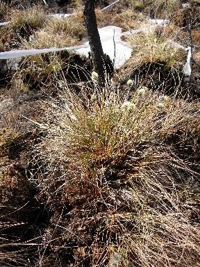 1 1
[1] a Eriophorum vaginatum tussock on Poker Flat after the 2004 wildfire. The tussock suvivied through the fire and vegetatively reproduced (Tsuyuzaki et al. 2013). ChinaCarex meyeriana tussock increased species richness on the top (Tsuyuzaki & Tsujii 1992). |
