(Upload on June 19 2026) [ 日本語 | English ]
Mount Usu / Sarobetsu post-mined peatland
From left: Crater basin in 1986 and 2006. Cottongrass / Daylily
ApplicationsWeather forecastingBiological meteorology (生物気象学) Agricultural meteorology (agrometeorology , 農業気象学): one of the branches of meteorology dealing with the relationship of weather and climate to crop and livestock production and soil management
seasonal forecast (half year, 3 months or 1 month) Maritime meteorology, etc. Spatial representativeness (空間代表性)the degree to which a measurement or sample reflects the characteristics of an area (or volume)Atmospheric monitoring stations: a point measurement is representative if the probability that the squared difference between the point and area measurement is smaller than a certain threshold, e.g., 90%, of the time. |
[ climatology | disaster ]  an eclispe seen at Sapporo on October 8 2014 |
energy input → changing with latitudes and seasonsShortwave radiation (短波放射)Electromagnetic radiation at shorter wavelengths (mostly 0.2–4 μm) associated with incoming solar energyLongwave radiation (長波放射)Electromagnetic radiation emitted by the Earth and its atmosphere at infrared wavelengths, typically peaking between 5–25 μm, as a function of temperatureEnergy balanceRn = H + IE + G + (Ain - Aout) + ΔSt + ΔPSt = ∫Z1z2[∂(ΣiρiciTi/∂t]dz + ∫Z1z2[∂(ρalq)/∂t]dz |
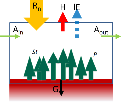 ➔ H: sensible heat flux
heats air
evapotranspiration
heats ground, melts snow and ice α = (reflected SW)/(incoming SW), ranging from 0 to 1 |
Wind-chill factor (体感温度)= wind chill or windchillDef. Lowering body temperature by the passing-flow of lower-temperature air a surface loses heat through conduction, evaporation, convection and radiation Missenard equation (1937), M, °F = t - 1/2.3·(t - 10)·(0.8 - y/100)
t = air temperature, °C Wind chill index, WCI = (10√v - v + 10.5)·(33 - t) |
Def. discomfort index (不快指数), DI: combination of temperature and humidity that is a measure of the degree of discomfort experienced by an individual = temperature-humidity index (温湿指数), THI
DI = 0.99t + 0.36t' + 41.5 or t' = dew-point temperature |
Def. A layer of gases that envelop an astronomical object and is held in place by the gravity of the object
Air pressure (pressure, 気圧)Def. force per unit area exerted by an atmospheric column (that is, the entire body of air above the specified area)Barometer (気圧計)Ex. aneroid barometer, Fortin barometer (フォルタン型水銀気圧計)Def. Reduction (of pressure) to mean sea level (海面更正) adjusting atmospheric pressure at various altitudes to a common reference level, i.e., sea level Sea level pressure (SLP, 海面気圧), ΔP= mean-sea-level barometric pressure (海面更正気圧) ΔP = P0 - P = P(exp(gh/RTm) - 1)
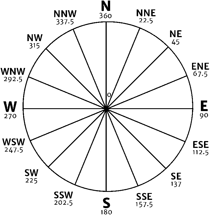
P0: pressure at sea level Wind direction, force and velocity (風向・風力・風速)Wind directionWind forceBeaufort scale of wind force (ビューフォート風力階級)an empirical measure showing wind speed (at 10 m above the sea surface) to observed conditions Ex. Beaufort number. description: wind speed, kt/m·s-1 (wave height, m): sea conditions; land conditions
|
Wind direction (風向)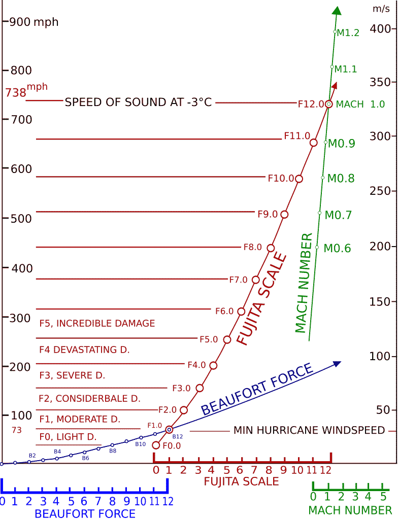 Fig. Connection of Beaufort force, Fujita scale and Mach number.
V = 1.87081.5 mpg = 0.836B1.5 m/s Wind velocityTerminology:Instantaneous (momentary) wind speed (velocity) (瞬間風速) → maximum instantenious wind or peak gust (最大瞬間風速) Maximum sustained wind, maximum wind speed (最大風速)Low (atmospheric) pressure, L(A)P (低気圧)Law. Buys Ballot's law (Buys Ballot CHD 1857)If one stands with one's back to the wind, in the Northern (Southern) Hemisphere the atmospheric pressure will be lower on one's left (right) Terminology: northerly/easterly/southerly/westerly (北/東/南/西風方向) southwestward (南西方向) |
Def. A visible mass of liquid droplets or frozen crystals made of water or various chemicals suspended in the atmosphere (→ aerosols) above the surface of a planetary body
|
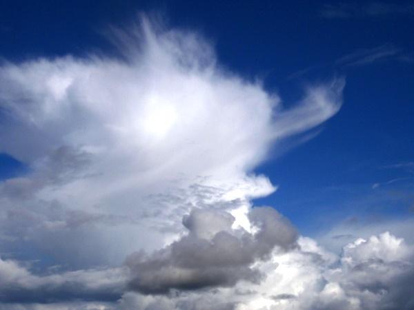
Cloud classificationcirro-: curl of hair, highalto-: mid strato-: layer nimbo-: rain, precipitation cumulo-: heap |
|
Natural aerosol = cloud, volcanic ash, (fire smoke - sometimes anthropogenic), etc.
Anthropogenic aerosol = factory emission, veichle exhaust, etc. ENSO → El niño, inducing severe wildfire (in southeastern Asia) |
Aerosol optical thickness (AOT) or depth (ADT)☛ Black carbon (ブラックカーボン) |
|
Def. Humidity (湿度), V: the amount of water vapor present in the air absolute humidity + relative humidity + specific humidity Def. absolute humidity (絶対湿度): the total mass of water vapor per unit volume of air, often expressed in g/m3Def. relative humidity, RH (相対湿度, %): the ratio of the current amount of water vapor in the air to the maximum amount it can hold at a given temperature Def. specific humidity (比湿): the mass of water vapor per unit mass of air, including both dry air and water vapor, often measured in g/kg |
Pan evaporation (計器蒸発量)A measurement that combines or integrates the effects of several climatic elements, such as temperature, humidity, rain fall, drought dispersion, solar radiation and wind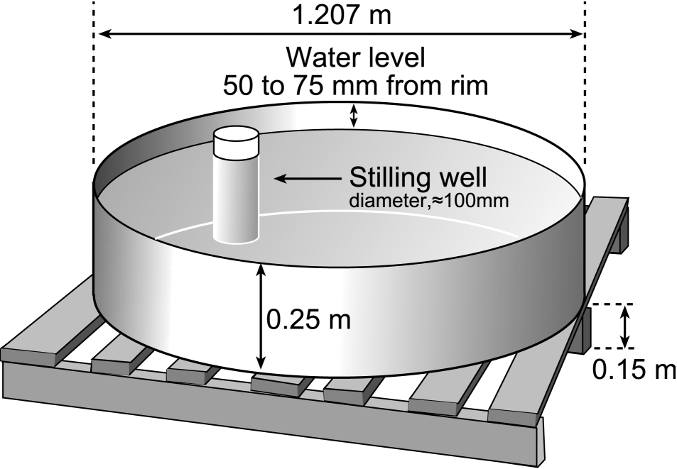
Application: agriculture - to know how much water the crops need |
the state of the atmosphere, describing for example the degree to which it is hot or cold, wet or dry, calm or stormy, clear or cloudy
Synoptic meteorology (総観気象学)
geostationary meteorological satellite, GMS (静止気象衛星) AMeDAS (アメダス)= Automated Meteorological Data Acquisition System (probably Japanglish)Research sites [ database ]Sarobetsu Mire: 45°06N, 141°42E, 7 m a.s.l.Toyotomi (豊富): 45°06.1'N, 141°46.8E, 14 m (7 km far from the post-mined peatland) temperature, precipitation, snowfall, snow depth, sunshine hour, wind speed, wind direction Horonobe (幌延): 45°00.4'N, 141°51.1'E, 5 m (13 km)precipitation Numakawa (沼川): 45°14.9'N, 141°51.1'E, 23 m (20 km)temperature, precipitation, snowfall, snow depth, sunshine hour, wind speed, wind direction |
Wakkanai (稚内): 45°24.9'N, 140°40.7'Ee, 2.8 m (> 30 km)
temperature, precipitation, snowfall, snow depth, sunshine hour, global solar radiation, wind speed, wind direction Mount Usu: 42°30'N, 140°50'E, 727 m a.s.l.Toya Spa (洞爺湖温泉): 42°39.9'N, 140°48.4E, 85 m precipitation, snowfall, snow depth Date (伊達): 42°28.5'N, 140°50.9'E, 3 mtemperature, precipitation, sunshine hour, wind speed, wind direction Mount Koma: 42°03'N, 140°40'E, 1133 m a.s.l.O-numa (大沼): 41°58.6'N, 140°42.9E, 165 m precipitation, snowfall, snow depth Mori (森): 42° 04.0'N, 140°35.3'E, 125 mtemperature, precipitation, snowfall, snow depth, sunshine hour, wind speed, wind direction Screen (instrument screen, 百葉箱) |
| the application of science and technology to predict the state of the atmosphere for a future time and a given location |
Expressionsettled weather (落ち着いた天気) ↔ hazardous or significant weather (悪天) |