(Upload on June 6 2025) [ 日本語 | English ]
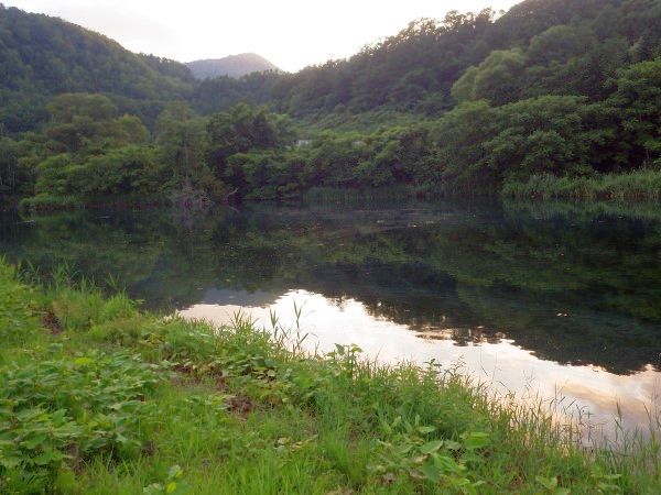
Mount Usu / Sarobetsu post-mined peatland
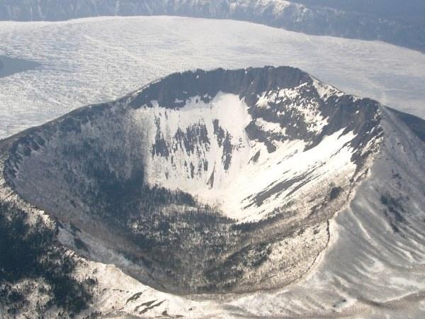
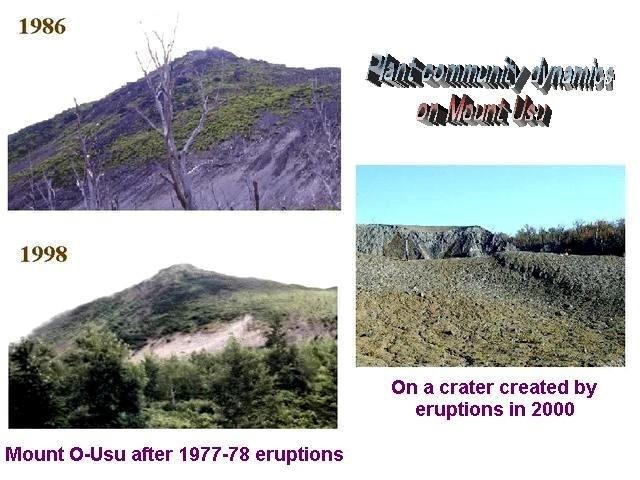
From left: Crater basin in 1986 and 2006. Cottongrass / Daylily
HOME > Catalog > Glossary > Volcanology > Volcanoes
VolcanoesOn mountain names, '-dake', '-take', '-san' and '-yama' mean 'mountain'. For example, Komagatake means Mount Koma.Hokkaido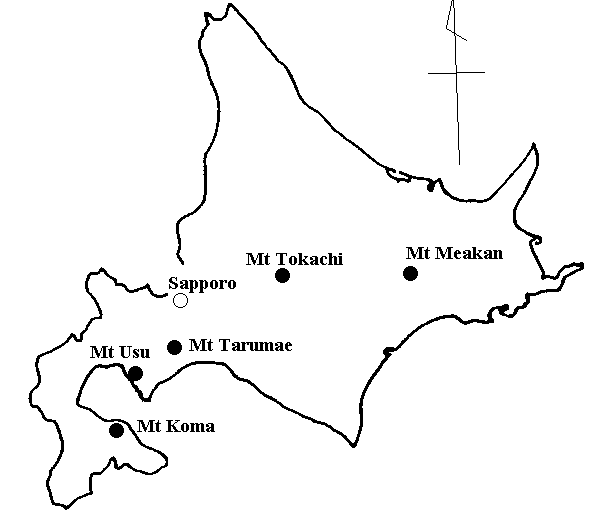 |
Mount
JapanVolcanoes of Japan
World
|
Volcano World (Oregon State Univ.) Volcano Live (John Seach) |
|
Quaternary stratovolcano (the nickname is Rishiri-Fuji) Late Pleistocene (130,000-18,000BP): alkali and non-alkali mafic volcanic rock Tephra chronology and palynology:
Aso
Rs-Ac2: the apogee of coldness Toya |
 Viewing from Wakasakanai Coast on May 25 2015. |
|
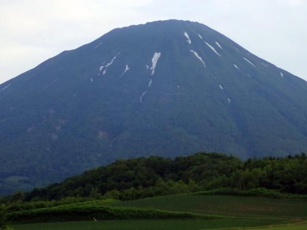
Eniwa-dake (エニワダケ, 恵庭岳)
Eniwa: etymology = e-en-iwa [a sharp-pointed rock (or peak)] |
 1 1
 2 2
[1] We can see fumarolic gas in the center of the photos. This mountain is an active volcano. [2] The dominant shrub is Salix reinii. (taken on May 29 1998) |
 1 1 |
 2 2 |
Mount Esan (618.1 m elevation) is a small stratovolcano faced to Tsugaru Straits in Hokkaido Island, and was assigned as Esan Prefectural Natural Park in 1961 when I was born. A minor phreatic eruption in 1846 induced a mudflow. The last (small) eruption took place in 1874. Sulfur buring occurred in 1876 and 1962. Nowadays, fumaroles emerge from the upper-northwestern flank. [1/2] famous to see ericaceous plants. Also, you should visit Sai-no-kawara (the Children's Limbo). (in early October, 1983. It was cold.) The grassland was dominated by Miscanthus sinensis. |
|
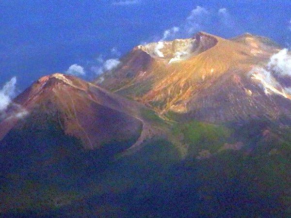
stratovolcano with lava domes (2077 m elevation, tallest volcano of the Tokachi Volcanic Group) |
1670: lavaflow 1857 1887 1926: eruptions → debris avalanche and lahar 1962: eruptions |
|
An active andesitic stratovolcano forming a lava dome (1041 m elevation) 1667: Ta-c1, Ta-c2 1739: plinian eruption of VEI 5 1909 (April 17-19): forming the present lava dome 1982: phreatic eruption, and more |
 |
|
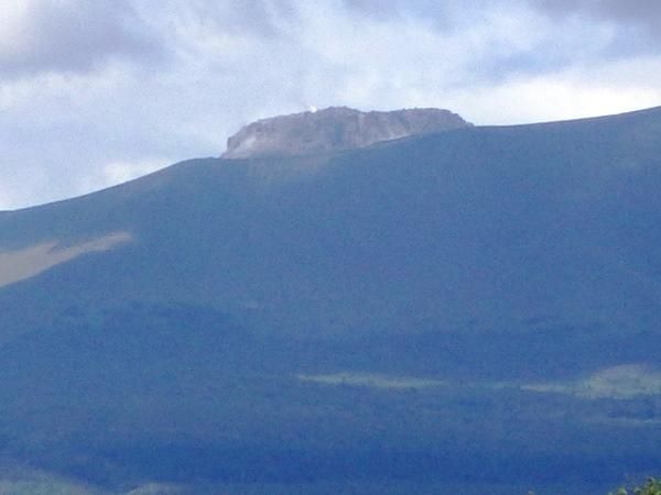
1898 m elevation (also called shiribeshi-yama or ezo-fuji → assigned as 100 nice mountains in Japan southern Shiribeshi District (northwestern Iburi Province) confical stratovolcano 2003 designated to active volcano (Meteorological Agency of Japan) |
|
 Active stratovolcano grouped into Akan Volcanic Complex in Kurile arc
CAUTIONThis mountain is an active volcano.Please watch out for flaling rocks, smoke and poisonous gas. |
 |
[succession, 遷移]
What is KOMA?Location = 42°03'48''N, 140°40'38''E. Elevation = ca 1140 m (1131 m)O-numa Quasi-National Park History of major eruptionsYear (Era): M (magnitude if known), Eruption type(s)Damage 1640 (Kanei 17): M5.4, collapse, blast, plinian (Ko-d)
Kurumi-slope debris avalanche → 1765? (Meiwa 2): small eructation (no detailed information) 1784 (Tenmei 4): M4.2, small eructation Sept 25 1856 (Ansei 3): formed small lava dome and Ansei Crater →
pumice fall (eastern Hokkaido) 1905 (Meiji 38): small eructation (Ko-b) → formed Meiji Crater 1919 (Taisho 8): small eructation, ceased in 1924 (Taisho 13) June 17 1929 (Showa 4): M4.5, pyroclastic flow, mudflow (Ko-a)
Showa-4 Crater → formed Showa-17 Crater and Showa Huge-rift (1.6 km long) 1996-2000 (Mori Climatological Observatory)Eruption type = phreatic explosion, and damaged area = the summit
Date Ejecta (ton) |
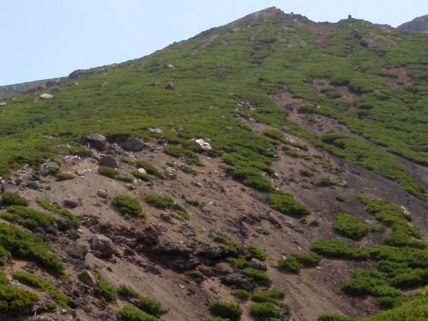
  1 1[1] Showa huge-rift formed by the 1942 eruption (on November 21 2005). → The characteristics of revegetation patterns |
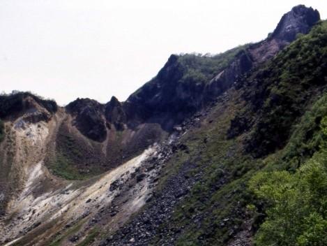
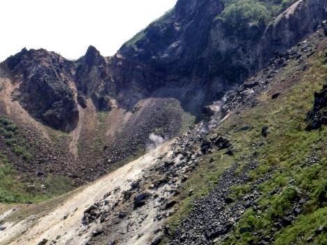
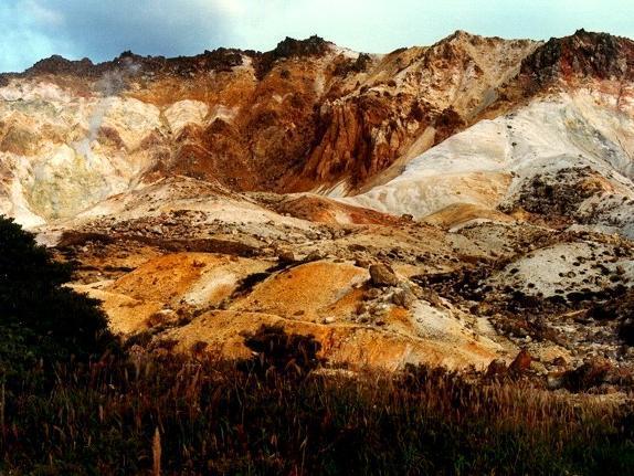
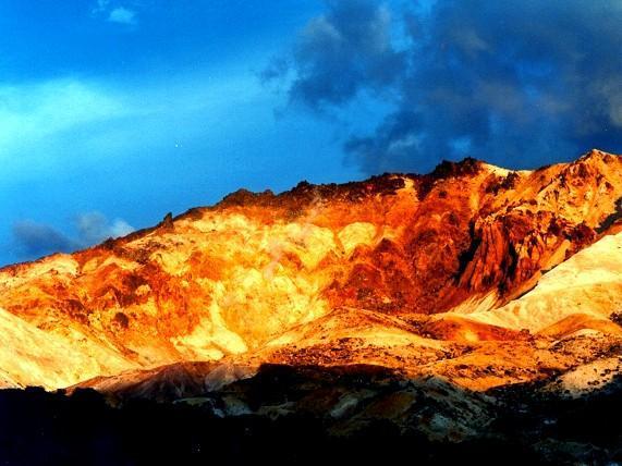
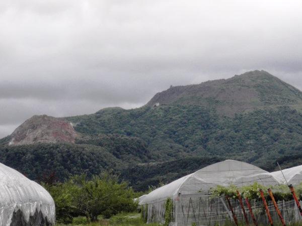
What is USU? [ Usu | Flora | Showa-Shinzan | Yosomi ] [succession, 遷移]
 1
1
 2
2
 3
3
| Year | 1663 | 17C | 1769 | 1822 | 1853 | 1910 | 1944-45 | 1977-78 | 2000 |
| Spot | Summit | Summit | Summit | Summit | North foot | East foot | Peak | West foot | |
| Construction | Ko-Usu | Ogari | O-Usu | Yosomi | Showa-shinzan | Usu-shinzan | |||
| Tephra (km³) | 2.5 | trace | 0.11 | 0.28 | 0.35 | 0.003 | 0.001 | 0.09 | < 0.001 |
| Death | 5 | 103 | 1 | 1 | 3 | 0 |
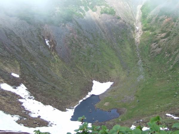
There are two groups of craters: Kompira and Nishiyama.
11/10/01: From the former kindergarden to the 2nd lookout _________________________
Toyako Twon Office
| Prediction (Yokoyama et al. 1973) | 1977-1978 eruption | |
| Eruption point | Summit or north flank | Summit |
| Types of eruptions |
30-50 years since 1945 Occurrence of forerunning shocks Eruption may begin 3-10 days after the starting of earthquake |
Eruption began 32 years after 1945 Forerunning earthquakes occurred Eruption began 30 hours after the starting of earthquakes |
| Nature of magma | Dacite | Dacite |
| Eruption and associated phenomena |
Explosive eruptions Ash fall deposits (thickness): several-several tens cm at the foot (3-5 m in case of major eruption) Flying distance of volcanic blocks: 1.5-2.5 km in maximum Occurrence of nuee ardente Uplift of ground - Formation of cryptodome Appearance of lava dome |
Pumice eruption followed by phreatic-phreato-magmatic eruptions Ash fall deposits: 30-50 cm at the foot Flying distance of volcanic blocks: 2 km in maximum No nuee occurred Uplift of the summit caldera bottom - A cryptodome (Usu-Shinzan) was formed Lava dome did not appear |
| Disasters caused by: | 1) earthquake shocks, 2) crustal movements, 3) pyroclastic fall, 4) nuee ardente, and 5) mudflow | 2) crustal movements, 3) pyroclastic fall, and 5) mudflow |
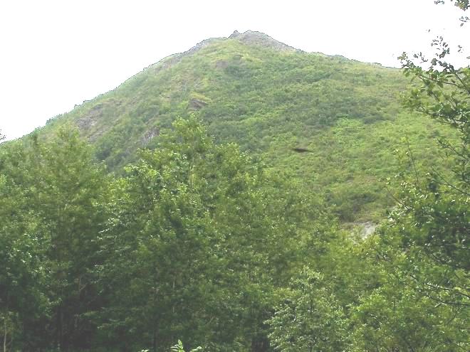
Showa-Shinzan (昭和新山)This mountain (398 m a.s.l.) is a volcanic lava dome close to Mount Usu, created during 1944 and 1945.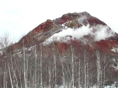 1 1
 2 2
 3 3
[1] Mount Showa-Shinzan created by 1945 eruptions. Mimatsu diagram recorded the process of the development of this mountain. Mt. Showa-Shinzan is gropued into the volcanic clusuter of Usu volcanoes. The forest was dominated by Betula platyphylla var. japonica and Populus maximowiczii. on December 18 2004 by Uraguhi A. [2] viewing from Sobetsu Town on July 3 2009. [3] veiwing from the caldera rim of Mount Usu on July 17 2013. Toya Caldera and Usu Volcano UNESCO Global GeoparkShinzan-numaAfter about 6 months-long intensive earthquakes and uplift deformation, an eruption occurred on June 23, 1944 in the wheat field in the eastern flank of Mt. Usu. Early eruptions were steam explosions, but the following larger ones produced pyroclastic surges. Two years-long uplift resulted to the birth of lava dome called Showa-Shinzan, now designated as a special natural monument of Japan, attracting many visitors. |
Dammed lake is a common phenomenon among the world volcanoes. The mechanism is mostly a blocked river by entering lava flows or debris. However, this Shinzan-numa pond is a quite unique and rare one. Sobetsu River was dammed up by the successive ground upheaval (called crypto-dome or hidden dome) as a part of Showa-Shinzan lava dome formation. The 2000 eruptions of Mount Usu created “Nishi-Shinzan-numa” again by same mechanism. Despite of the world war, challenging researchers were performed on Showa-Shinzan activity. A local postmaster Mr. Masao Mimatsu found a pattern of radial fissure, and Prof. Takeshi Minakami estimated hypocenters of shallow earthquakes clustered at that deformation center and increasing in number several days prior to the eruption. So, basic eruption forecasting “where” and “when” was a promising one. If you have more interest, we recommend you to visit “Mimatsu Memorial Hall” in the Showa-Shinzan square, where abundant observational data are displaced. |
About 45 volcanic craters were created by the eruptions in Meiji 43 (1910).
|
2568 m elevation 1783.8.15: mudflow → killed ≈ 1,400 people |
|
1915 m elevation 1408-1410: formed Mount Chausu |
|
Location 80 km SW of Tokyo (in Kanagawa Prefecture) Volcano type: massive stratovolcano truncated by 2 overlapping calderas |
[ geopark ] |
|
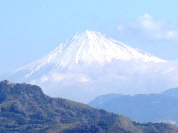
Elevation: 3776 m - active stratovolcano Coordinates: 35°21'29"N, 138°43'52" |
|
|
[succession, 遷移] Miyake Island (三宅島)Recent eruptions1983: fissure eruption, and lavaflow2000: a caldera was created, and the eruptions were characterized by the production of enourmous volcanic gas (SO2) Izu-oshima Island (伊豆大島)1684-90: Kyoho mega-eruption1695-: Anei mega-eruption → Anei lava 1912-14: eruption 1950-51: producing Showa lava 1986: eruption Eruption so large that lava flows reached the sea (海まで達した大噴火) Pahoehoe lava flows of Great Anei Eruption have many small mounds which are compound feature of multiple overlapping. They also have the ropy texture on the surface and small lava tubes. The tubes formed when the lava crust solidified quickly white the interior kept flowing, leaving empty space beneath the crust. Sit on the smooth surface of lava and take your time to observe! (Beware of vipers!) The lava from this area further filled in the low areas in the caldera and flowed down to the northeast, reaching the sea near the present-day Oshima Park. Lava from the southern foot of Mt. Mihara also flowed over the caldera wall and reached near the present-day Oshima Loop Road. A large amount of volcanic ash began to be emitted in 1783, accumulating 1.2 to 1.5 m thick at the foot of the volcano. 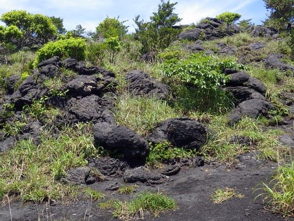
 (at the middle of Mount Mihara on June 7 2023) 1986 Lava flow tip (1986年溶岩流先端部)On November 19, 1986, the lava overflowing from the summit crater flowed down the slope of Mt. Mihara and covered the older trail and stopped here. The tip of the lava flow is about 5 m thick. The substrates composed of lumps of rough rubbly rocks. Why don’t you climb on top of the lava and image the flow of lava during an eruption?As the lava flows, the surface exposed to the air cools first and solidify to a crust. However, since the inside of the lava keeps high temperature, it still moves, so that crust surface is crushed and a lot of rugged clinker is accumulated. |
The Great Road Cut (地層大切断面) Latitude 36°41'11"N Longitude 139°22'18''E Above sea level 71.6 m
Huge and valuable cross-section of the volcanic historyOver the past 18,000 years, more than 100 large eruptions have created a huge and beautiful layered structure. This formation was unexpectedly discovered in 1953, when the mountain was being cut down to build a road around the island.About 17,000 years ago, a major eruption occurred at the top of the mountain, forming a caldera. The volcanic blocks blown away and pyroclastic flows deposits during the eruption are preserved in the upper west end of the stratum. Umi no Furusato Mura (Oshima Park) 海のふるさと村(大島公園)Coastal Trail (海岸遊歩道)Oshima coastal plant communityThe coastal plant community in Kasamatsu was designated a national natural monument in 1951. This plant community starts at the shoreline with significant coverage of Juniperus lutchuensis var. maritima (オオシマハイネズ), which stretches up to 20 m inland and also includes other coastal plants like Lilium maculatum (スカシユリ) and Chrysanthemum pacificum (イソギク). Further inland and the landscape is characterized by shrubs such as Pittosporum tobira (トベラ), Rhaphiolepis indica var. umbellata (マルバシャリンバイ) and Hydrangea macrophylla f. normalis (ガクアジサイ), as well as flowering plants like Polygonatum odoratum (アマドコロ) and Fartugium japonicum (ツワブキ). Coastal plant communities like these can also be seen along the coast from Ishirodo (石廊戸) to Gord (ゴード) and Komagetaro (駒毛太郎).Castanopsis sieboldii forestWe can see Castanopsis sieboldii forests in deep valleys and Saxifraga fortunei var. jotanii (イズノシマダイモンジソウ) growing on the cliff walls leading down to the valley.Blowhole (潮吹きの鼻)A blowhole at the bottom of the cliffs has been formed by a small cave that comes into contact with the ocean surface at the foot of the lava cliffs. When the waves are breaking on this cave the air inside becomes compressed, which then escapes by squirting up into the air with a strange sound. The cave is 7 m high and 6 m wide and goes back a long way too. When the tide is high or when the waves are strong, sometime the blowhole spouts up to 10 m in the air.ViewpoitAs you pass through the tunnel of trees, the ocean vista opens up before you. On a clear day you can see as far as the Boso Peninsula in Chiba.Gyojahama (行者浜)There is a legent that En the Ascetic (役行者, En no Gyoja) performed his training in the cave here (Gyoja Cave). However, the cave itself is no longer accessible due to the danger of falling rocks. Each year in Une the Gyoja Festival takes place on the beach. If you pass through the Gyoja-kaigan tunnel you reach Memezu Beach.(June 8 2023) |
|
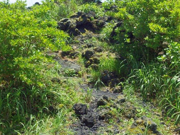
2013.11.20: emerged 2013.11.26: 200 m long × 170-180 m wide 2013.12.24-25: 15 ha → connected with the former Nishinoshima Island (therefore called Nishinoshima Island because of the nomenclature) |
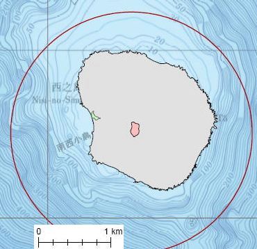 The 7th crater (pink): 27°14.6'N, 140°52.7'E
The former Nishinoshima (green) Nishinoshima (gray) less than 1.5 km long from the crater (red circle) (2016.02.17. Japan Coast Guard) |
|
Caldera: 25 km north-south and 18 km east-west (rough estimation) Central cone group of Aso volcano = Aso Gogaku, Aso Five Peaks (阿蘇五岳)
Mount Neko (根子岳) Aso-Kuju National Park Aso Caldera (阿蘇カルデラ)Aso region has one of the world's largest calderas, measuring approximately 25 km from north to south and 18 km from east to west. The central volcanic cone group formed including the highest peak, Mt. Takadake (,1592 m elevation) as well as the caldera floor and outer rim surrounding it. This caldera was created by the collapse of hollow magma reservoir resulting from four massive pyroclastic flow eruptions occurring between about 270,000 and 09,000 years ago. The outer rim surrounding the caldera have the elevation difference of 300 to 500 m from the foot. The outside features of gentle pyroclastic flow terraces and the inside caldera are steep gradient walls. |
Rakudayama (らくだ山) “Rakudayama (Camel Mountain)” is the name of what you can see in front (photo). Origin of the name from vertical sheet rock formations on the summit resemble the back of a camel. Those rocks are over 5 meters wide and 10 meters long or more. These vertical sheet rocks (intrusive rocks) had solidified of magma intrude to cracks or gaps into bedrocks in crust without reach to terrain. Those surrounding rocks (tuff-breccia) have been speculated that had emerged from long-term processes of weathering and erosion from underground magma. You can observe the surface of tuff-breccia (dykes) up close and examine the cracks in the bedrock (columnar joints). (Ministry of the Envkironment 2024.09)
|
|
An active composite volcano (stratovolcano) Formerly it was an island in Kyushu The lava flows in 1914 connected the island with the Osumi Peninsula |
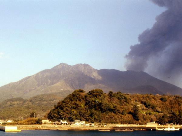
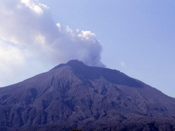
in early April 1985. |
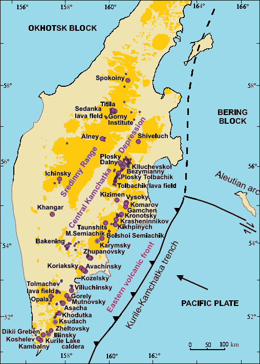 ● large volcano active in Holocene ◉ large volcano in Holocene caldera • Holocene monogenetic volcano (cinder cone, maar, crater or lava dome) ▇▇▇ late Pliocene-Holocene volcanic fields Holocene Volcanoes in Kamchatka |
Mount Kliuchevskoi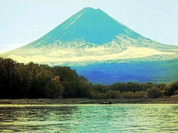 The volcano Mount Kliuchevskoi (ca 4800 m) and Kamchatka River (a letter photo from Grishin S). Volcano Bezymianny (ベズイミアニ)stratovolcano (≈ 2882 m a.s.l.)1955 eruption → 1956 sector collapse 2022/05/28 ≈17:00: eruption |
|
= Paektu Mountain (白頭山) stratovolcano, 2744 m elevation (41°41'-42°51'N, 127°43'-128°16'E) 946AD (prob.): VEI = 7 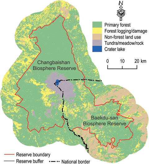
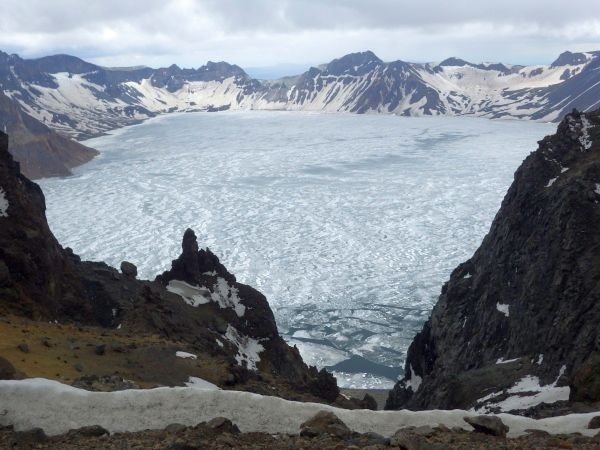
Changbaishan Tianchi (長白山天池)caldera lake, frozen from mid-October to mid-Junethe source of the Songhua, Tumen and Yalu River 12-14 km in perimeter, 213 m in averaged depth |
on June 12 2017 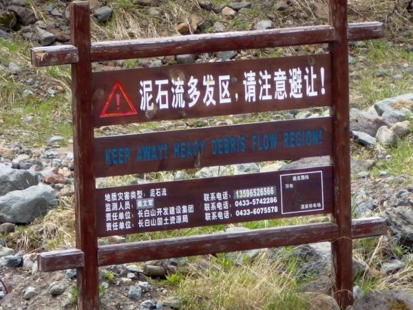 Mudflows frequently occur in this area. We saw many plates that show the attention.
Keep away! Debris flow region! The Dell forest"Dell Forest" is alos called the underground forest. The ground subsided and formed the valley during the volcanicity and orogenetic movements. The depth of valley is 60 meters and the width is about 3000 meters. Such spectacle of the nature! Thick forest, stones and fresh air in the valley bottom. Standing on the edge of the dell forest, you can see the whole scene. Rare plants and animals lives here. It is a really valuable land.Fallen Trees - Forest SeedbedsThe betula ermanii, spruce-fir forest in the Changbai Mountain is one of the rare forest vegetations of the subalipine in north China. The understory has a large number of fallen trees. Due to the competitions from herbaceous plants on seedlings and the threats from rainy season moistures on seeds and seedlings, the fallen trees serve as main seedbdes in the forest. Although fallen trees cover an area of only 7.21% of the forest, the number of seedlings growing of the total number of seedlings in the forest. At the same time, the fallen trees constitute the main habitat of microorganisms. Artificial removal of fallen trees will deprive the decomposers (microorganisms) of decomposition objects the food chain, making it impossible for such nutirents as C, N, P and others to return to nature, and breaking the original sustainable material cycle and energy transffer processes, so the fallen trees in virgin forests cannot be cleared away!(nothing has changed on the board. on June 12 2017.) |
[succession, 遷移]
Mount St. Helens made catastrophic eruption on May 18, 1980. By the creation of horseshoe crater, the elevation changed from 2950 m to 2550 m. Before the eruption of Mount Pinatubo, Philippines, this eruption was the largest in 20th century. A massive debris avalanche derived from the eruption.
|
A volcano
Active during 1820 and 1854 Highest mountain (4,392 m a.s.l.) in the Cascades that are a part of the Pacific Ring of Fire Mount Rainier National Park established on March 2 1899 VegetationFederation Forest Stage ParkLowland old-growth vegetation on the Natches Trail (Tsuga heterophylla zone)Trees-Shrubs: Tsuga heterophylla-Acer circinatum. Pseudotsuga menziesii-Oplopanax horridum. Pinus contorta-Rosa nootkatensis. Picea sitchensis-Vaccinium parvifolium. Thuja plicata-Gaulteria shallon. Abies grandis-Berberis nervosa. Alnus rubra-Holodiscus discolor. Acer macrophyllum-Salix sp. Taxus brevifolia. Lonicera ciliata Herbs: Achlys triphylla. Adenocaulon bicolor. Athyrium flix-femina. Blechnum spicant. Clintonia uniflora. Coralorhiza sp. Cornus unalaschkensis. Goodyera oblongifolia. Hieracium albiflorum, Lactuca muralis. Linnaea borealis. Lysichitum americanum. Polystichum munitum. Prunella vulgaris, Pteridium aquilinum. Rubus ursinus. Smilacina stellata. Streptopus roseus, Tiarella trifoliata, Trientalis latifolia. Trillium ovatum, Viola spp. Silver Fir Campground (elevation ca 650 m)Old growth Tsuga heterophylla zone forest at upper near limit. Soils are derived from various volcanic activities.Trees-Shrubs-Herbs: Tsuga heterophylla-Acer circinatum-Achlys triphylla, Pseudotsuga menziesii-A. glabrum-Asarum caudatum, Thuja plicata-Aruncus sylvestre-Athyrium flix-femina, Abies grandis-Berberis nervosa-Blechnum spicant, Pinus contorta-Gaulteria shallon-Clintonia uniflora, Alnus rubra-Chimaphila umbellata-Cornus unalaschkensis, Populus trichocarpa-Linnaea borealis-Fragaria virginiana, Oplopanax horridum-Galium triflorum, Rosa gymnocarpa-Gymnocarpium dryopteris, Rubus parviflorus-Hieracium albiflorum, Salix sp.-Maianthemum dilatatum, Sambucus racemosa-Petisites frigida, Taxus brevifolia-Polygonum munitum, Vaccinium parvifolium-Prunella vulgaris, Pteridium aquilinum. Rubus ursinus. Smilacina stellata. Tiarella trifoliata. Trientalis latifolia. Viola glabella. Streptopus sp. |
White River Road (1200 m)Vegetation in this area falls into the Abies amabilis zone.Trees-Shrubs-Herbs: Abies amabilis-Alnus sinuata-Anaphalis margaritacea. Abies lasiocarpa-Gaulteria shallon-Asarum caudatum. Abies procera-Mensiesia ferruginea-Chimaphylla umbellatum. Rubus parvifolia. Chamaecyparis nootkatensis-Gaultheria humifusa. Pinus monticola-Rubus spectabilis-Linnaea borealis. Populus trichocarpa-Salix hookeri-Pyrola secunda. Pseudotsuga menziesii-Sorbus sitchensis-Viola spp. Thuja plicata-Vaccinium membranaceum. Tsuga heterophylla-Vaccinium alaskense. Tsuga mertensiana. Sambucus racemosa. Taxus brevifolia. Vaccinium parvifolium Sourdough Ridge (1800 m)Vegetation here begins to resemble that of the Abies lasiocarpa zone.It is too dry for a Tsuga mertensiana zone, though this species occur in favorable sites.Trees-Shrubs-Herbs: Abies lasiocarpa-Alnus sinuata-Anapaahlis margaritacea. Tsuga mertensiana-Juniperus communis-Arnica diversifolia. Abies amabilis-Sorbus sitchensis-Aster foliosus. Chamaecyparis nootkatensis-Spirea densiflora-Castilleja miniata. Pinus albicaulis-Cassiope mertensiana-Luetkea pectinata. Picea engelmannii-Vaccinium membranaceum-Luina stricta. Lupinus latifolius. Luzula sp. Polemonium pulchellemum. Sitanion hystrix. Veratrum viride. Vaccinium deliciosum Sunrise (1900 m)This is a dry subalpine meadow complex, with isolated tree groups. The substrate is a recent pumice. Disturbance easily destroys the vegetation and recovery is very slow. We will view a 40 years old disturbance to determine the degree of recovery.Trees-Herbs: Pinus albicaulis-Lupinus latifolius. Abies lasiocarpa-Potentilla flabellifolia. Picea engelmannii-Anemone occidentale. Chamaecyparis nootkatensis-Antennaria lanata. Aster alpigenus Shrubs: Aster foliosus. Cassiope mertensiana-Carex mertensiana. Phyllodoce empetriformis - Castilleja parviflora. Juniperus communis-Hieracium gracile. Sorbus sitchesis-Juncus parryi. Vaccinium myrtillus-Agoseris sp. Ligusticum grayii Herbs: Phlox diffusa. Festuca viridula-Polygonum bistortoides. Sitanion hyxtrix-Polygonum newberryi. Pedicularis contorta. Veronica cusickii |
A volcanic island in the Hauraki Gulf near Auckland, New Zealand
It is an iconic landmark of Auckland as its distinctive symmetrical 260 meter high shield volcano cone is visible from much of the city. It is the most recent and the largest (2311 hectares) of the approximately 48 volcanoes of the Auckland Volcanic Field.
This island is also covered with weeds and/or exotic plants. (Clarkson 1990)
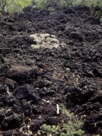
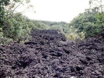 1
1
 2
2
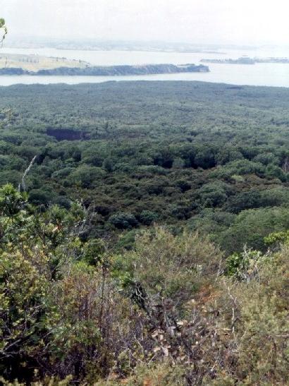 3
3
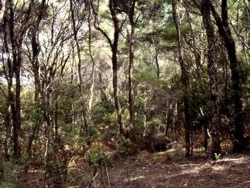 4
4
[1/2] lava flow. Lichens pathces sparsely establish on the lava. [3/4] forests develop on the island. (on January 31 1997)