(Upload on July 10 2026) [ 日本語 | English ]
Mount Usu / Sarobetsu post-mined peatland
From left: Crater basin in 1986 and 2006. Cottongrass / Daylily
HOME > Lecture catalog / Research summary > Glossary > Geological timescale
Paleontology (古生物学)≡ the study of animals and plants that lived in prehistoric timesAgassiz, Jean Louis Rodolphe (1807-1873) Swiss-born American biologist and geologist 1837 proposed the presence of ice age (glacial age) - glaciology 1842-1846 Nomenclator Zoologicus
a classification list of zoological genera and groups 1963 Ager: noted a continuing dichotomy between systematic paleontology and ecologically minded paleontology
We must consider fossils as living organisms 1964 West: the historical development of Quaternary palaeobotany
→ parallels that of ecology Paleobotany (古植物学)Late 19 c: Advance in Europe (esp., German) → establishedEarly 20 c: Advance the techniques of microscope and thin section → introduced to Japan ObjectivesPaleobotany = botany + geology
|
[ era | chronology | extinction event | fossil 化石 ] major Subjects
Paleoecology (古生態学)≡ the study of interactions between ancient organisms and their environments across geological timescales |
|
Etymology: chronos (Gr. χρóνς, time) + (Gr. -logica, λογíα, logics) Definition: the determination of the temporal sequence of past events
chronology of planets MethodsPotassium argon dating (K-Ar dating, カリウム-アルゴン法)Rubidium strontium dating (Rb-Sr dating, ルビジウム・ストロンチウム法) Carbon 14 dating (炭素年代測定) |
Direct measurement of seedbank ageAbstract. We describe a new approach to determining the age structure of seed banks of natural plant populations and apply it to a natural population of the Sonoran Desert winter annual, Pectocarya recurvata (Boraginaceae). Unlike other 14C techniques, tandem accelerator mass spectrometry (TAMS) counts the number of carbon isotope atoms, permitting high precision with small samples. Aboveground nuclear bomb tests caused atmospheric 14C levels to peak in 1963. Their subsequent gradual decline provides a signal for aging seed banks with TAMS. We constructed a calibration curve using seeds with known dates of production during 1980.1995, then used it to age 53 seeds sampled from a natural seed bank in 1993, at the Desert Laboratory in Tucson, Arizona. Seed number declined with age at an approximately exponential rate, with the oldest recovered seed having an estimated age of 5 yr (95% CI = ± 2.3 yr). The seed bank age structure was judged more than adequate to buffer this population from typical fluctuations, based on an examination of 15 yr of population dynamic data. The TAMS technique has strong potential for answering a broad range of ecological and evolutionary questions requiring post-1963 age determinations and for which a several-year confidence interval is acceptable. |
|
The Geologic Time Scale is an artificial division of the continuous history of the planet. Divisions are based mainly on changes in life. Divisions between Periods are often associated with major events such as extinction. The boundaries are real places to geologists. The Proterozoic-Cambrian boundary is marked at a remote spot in a cliff face on the Burin Peninsula, Newfoundland where the change in fossil life marks the beginning of the Cambrian. It is placed between the appearance of the Ediacaran fauna and the first appearance of trilobites. Within this time span of 30-50 million years, the boundary is recognized by the appearance of small shelly fossils. Other fossil markers include the first appearance of worm tubes, called sabelliditids, various kinds of trace fossils and the later appearance of trilobites. (St John Museum. Sept 19 2014) |
Cryptozoic time (隠生代) = Hadean + Archaean + Proterozoic Hadean (冥王代) Arcaheozoic (始生代) Proterozoic (原生代) Phanerozoic time (顕生代) = Paleozoic + Mesozoic + Cainozoic Cainozoic (新生代) Mesozoic (中生代) Paleozoic (古生代) Chronology (年代学) |
Hadean (冥王代): the birth of earth to 3.8 billion= Pre-archean and PriscoanArchaean, or Arcaheozoic (始生代) 3.8(4.0)-2.5 Byathe Earth crust had cooled enough to allow the formation of continentsCanada2.5 Bya (late Archaean): Kenoran orogenic movement (= formerly Algoman diastrophism)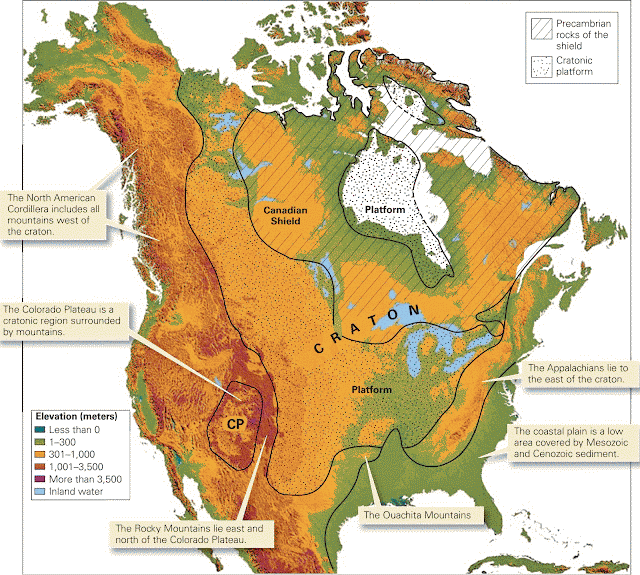 Fig. North America craton consists of a shield, where Precambrian rock is exposed, and a platform, where Paleozoic sedimentary rock covers the Precambrian Least fossils - difficulties in aging Rocks aged by potassium argon dating method and rubidium strontium dating method the distribution of ages is discontinous - intermittency of earth crust movement and orogenesis |
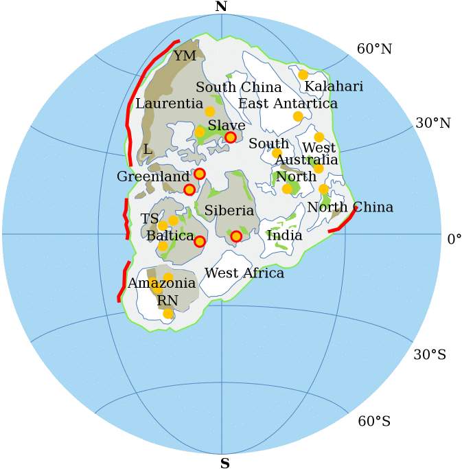
Proterozoic (原生代) 2.5 Bya-542 Myajust before the proliferation of complex life on Earth1.9 Bya: first birth of continent Nuna/Neuna (= North Europe and North America) 1.8-1.5 Bya: Columbia Continent (= Hudsonland)
1981 McWilliams: proposed 1991 Hoffman: proposed |
|
Caledonian orogeny (カレドニア造山運動): early Paleozoic Variscan orogeny (バリスカン造山運動) = Hercynian orogeny 4-2 Bya (Carboniferous - Permian)
between Eurasia (Laurasia) and Gondwana deposits contaning plant fossils in wet sites, such as oasis = southern part of Central Europe Pangea/Pangaea [230 Mya], Gr. pan + gaiaPermian - Triassic 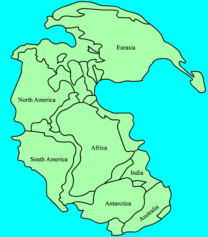 Only one supercontinent: split, drift and breakup Cambrian (カンブリア紀) 0.542-0.4883 ByaOrdovician (オルドビス紀): 485.4–443.8 Mya[extinction event]Tremadocian (478.6-488.3 Mya) Floian (471.8-478.6 Mya) Dapingian (468.1-471.8 Mya) Darriwilian (460.9-468.1 Mya) Sandbian (455.8-460.9 Mya) Katian (445.6-455.8 Mya) Hirnantian (443.7-445.6 Mya) Silurian (シルリア紀): 443.8–419.2 Mya= Gotlandian + Ordovician, or GotlandianGotlandian (ゴトランド紀) 4.4370-4.1600 Bya |
Devonian (デボン紀): 419.2–358.9 MyaWenlockian 433.4-427.4 MyaLudlovian 427.4-423.0 Mya Kawauchi Series = Wenlockian + Ludlovian Gedinnian 416–411.2 MyaTakainari Series CoblenzianEifelian 3.933-3.877 Bya Givetian: 3.877-3.827 Bya Frasnian: 3.827-3.722 Bya (upper Devonian) Famennian 3.722-3.589 Bya Tobigamori Series = Famennian + Frasnian Carboniferous (石炭紀): 3.67-2.89 ByaPermian (二畳紀/ペルム紀): 299–252 MyaThe world was dominated by two continents, Pangaea and Siberia, surrounded by a global ocean, PanthalassaSigillaria were important trees in the late Pennsylvanian forest. They were smaller than some of the other lycopods, growing about 20 to 30 m tall. The bark of fossil Sigillaria is easy to recognize. Unlike the other common lycopod, Lepidodendron, leaf scars of Sigillaria appear to be arranged in vertical rows. All of the lycopod trees, except for Sigillaria, became extinct before the end of the Pennsylvanian Period. (St John Museum, Sept 19 2014) Lycopod trees like Lepidodendron dominated the lowlands during the Pennsylvanian Period. They were large, growing to more than 50 meters tall with a trunk 1 to 2 meters in diameter. The “root” system extended as far as 12 meters into the floor of the swamps where they grew. The bark of Lepidodendron-like trees is easy to recognize. The spiral, diamond-shaped pattern shows where leaves were attached to the trunk and brnaches. Although the name Lepidodendron is used for the entire tree. The parts of large trees are usually found separated from other parts of the tree. Detached roots, leaves, cones and spores have all been given separate names. Detached roots are known by the name Stigmaria. These fossils are often found in clay, believed to be soil in which the trees grew. The overlying coal layer represents the decayed and compressed swamp vegetation. Detached leaves are sometimes called Cyperites, while cones are known as Lepidostrobus. (St John Museum, Sept 19 2014) The most important swamp trees were lycopods, Lepidodendron and Sigillaria. Today lycopods in New Brunswick are represented by tiny plants, but more than 300 mya Lepidodendron grew more than 50 meters tall. During most of the Pennsylvanian Period Lepidodendron-like trees made up eighty percent of the forest. As the Earth’s climate swung from wet to dry, the forest composition changed too. During a second dry interval in the late Pennsylvanian most of the lycopods became extinct, and were replaced by ferns. Coal deposits, characterized the Pennsylvanian Period, deposited mostly in lowland swamps where fallen tree trunks accumulated in large numbers. Fossilized roots of Lepidodendron are often found in clay soils, believed to have been the bottom of the Pennsylvanian swamps. Overlying coals represent the decayed and compressed swamp vegetation. Some layers even show evidence of ancient forest fires (森林火災). (St John Museum, Sept 19 2014) |
Gondwana·Laurasia [200 Mya] (Wegener 1912)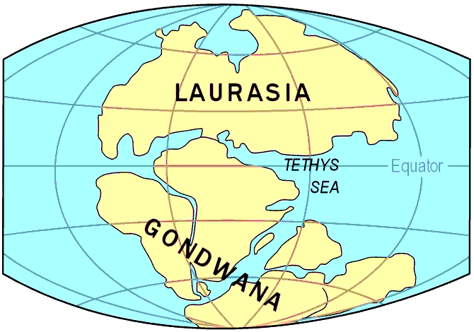 Gondwana layer in India: lime layer and mud-sand layer Plant fossils: woody ferns (Glossopteris, Gangamopteris) gneissic (片麻岩) and granite |
Triassic (三畳紀) 2.51-1.95 ByaSalzburg Salz (salt) - red sandstoneTethys Sea (テチス海) = Tethys Ocean or Neo-Tethys started the development in late Devonian (Paleozoic) prehistoric ocean during the Mesozoic Era and early Cenozoic Era, located between the ancient continents of Gondwana and Laurasia Jurassic (ジュラ紀) 1.95-1.35 ByaCretaceous (白亜紀) 1.4-0.65 ByaCretaceous–Paleogene boundary145-65 Mya warm climate → high eustatic sea levels |
Tertiary (第三紀), 64.3-2.6 MyaPaleogene (古第三紀), 66-23 MyaThe age of mammals (哺乳類)Palaeocene (暁新世) 66-56 Mya Danian 66-61.6 Mya Selandian 61.6-59.2 Mya Thanetian 59.2-56.0 1874 Sclater, Philip Lutley: proposed Lemuria (Limuria)
lemur fossils in Madagascar and the Indian continent but not in Africa or the Middle East - Lemuria made the bridge between Madagascar and India Ypresian 56.0–47.8 Mya Lutetian 47.8-41.2 Mya Bartonian 41.2-37.71 Mya Priabonian 37.71-33.9 Mya Oligocene (漸新世) 34-23 Mya Rupelian 33.9-28.1 Mya Chattian 28.1-28.93 Mya Neogene (新第三紀), 23.0-2.6 MyaMiocene (中新世) 23-5 MyaPliocene (鮮新世) 5-2.58 Mya Quaternary (第四紀) 65 million-presentPleistocene (更新世) 2.58-0.0117Gelasian (ゲラシアン): 2.58–1.80 MyaLower boundary: extinct haptophytes (ハプト藻), Discoaster pentaradiatus and D. surculus Calabrian (カラブリアン) 1.80–0.781 Mya (± 5 Kya)
Upper boudnary: magnetic pole reversal (781 ± 5 Ka) Tarantian (タランチアン) 0.126–0.0117 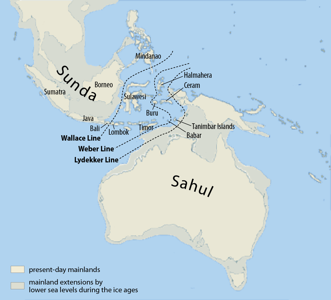 Fig. Sunda and Sahul. Ice age = 70000-14000 BP |
Beringia (Bering land bridge, ベーリンジア/ベーリング陸橋)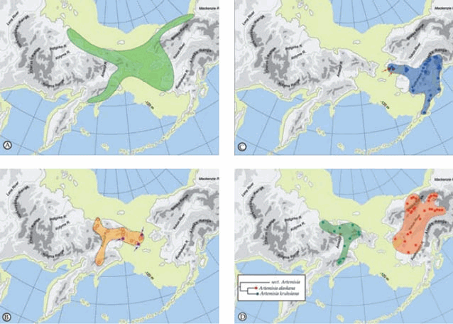 Fig. Large scale biogeographic patterns in Beringia with the maximum extent of the Bering Land Bridge during the Last Glaciation (18000-15000 years ago) showing in yellow (modified from Elias and Crocker 2008)  Fig. Minimum (interglacial, black) and maximum (glacial, grey) glaciation of the northern hemisphere during the Quaternary climatic cycles (18000-15000 years ago) Holocene (完新世): 0.0117–0 (Ma)Jomon marine transgression (縄文海進)7000-4000 YBP (peak = 6500-600 YBP) = Holocene glacial retreat Warm period (1-2°C > at present) → 2-3 m a.s.l. > at present Anthropocene (人新世)relating to or denoting the current geological age, viewed as the period during which human activity has been the dominant influence on climate and the environmentEtymology: anthropo- (Gr. human) + -cene (Gr. new or recent) Table. Potential Anthropocene beginning with proposed GSSP markers
2016 AWG: The great acceleration = beginning of Anthropocene |
≈ astronomy
The origin of the universe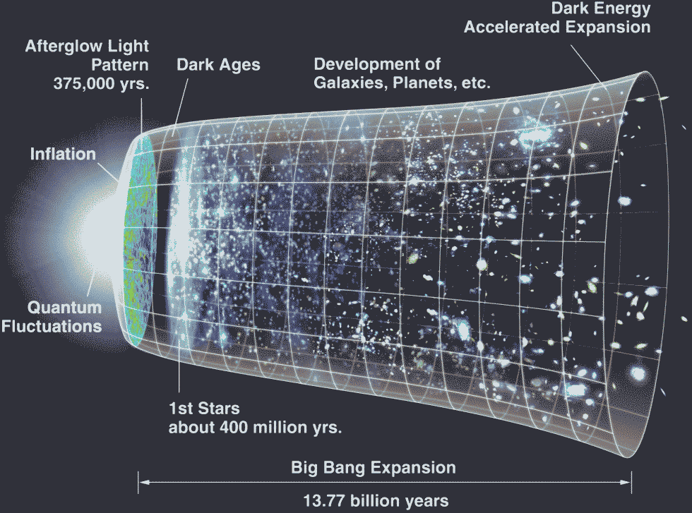 Fig. Timeline of the metric expansion of space, where space (including hypothetical non-observable portions of the universe) is represented at each time by the circular sections. On the left, the dramatic expansion occurs in the inflationary epoch; and at the center, the expansion accelerates Big bang theory, BB theory (ビッグバン理論)All of the current and past matter in the universe came into existence at ≈ 13.8 billion years ago(Sato 1981, Guth 1980) Inflationary universe theory (インフレ宇宙論)Astrobiology (宇宙生物学)Fermi paradox (フェルミのパラドクス)Drake equation (ドレイク方程式)a probabilistic equation to estimate the number of active, communicative extraterrestrial civilizations in the Milky Way galaxyN = R*·fp·ne·fl·fi·fc·L N = the number of civilizations in our galaxy with which communication might be possible |
R* = the average rate of star formation in our galaxy fp = the fraction of those stars that have planets ne = the average number of planets that can potentially support life per star that has planets fl = the fraction of planets that could support life that actually develop life at some point fi = the fraction of planets with life that actually go on to develop intelligent life (civilizations) fc = the fraction of civilizations that develop a technology that releases detectable signs of their existence into space L = the length of time for which such civilizations release detectable signals into space
R* ≈ 1-10 year-1 When L = 1 million years, N = 5 million Space colonization (宇宙移住)1969 O'Neill, Gerard K.: proposed large-scale space habitats
1974 The colonization of space (Island in space)
Population: several thousand
Population: Around 10000
Perfectly artificial, closed ecosystem
rotational artificial gravity * The space colonies in Mobile Suit Gundam (such as Side 3) were modeled after Island Three design |
|
Def. Planet (惑星): an extremely large, round mass of rock and metal, such as Earth, or of gas, such as Jupiter, that moves in a circular path around the sun or another star Def. Meteorites (隕石): a piece of rock or other matter from space that has landed on earth Records of meteorites (隕石の記録) 2013.09:20 (YEKT): Chelyabinsk meteor stroke Ural region 2008.10.07 TC3 stroke Nubian Desert in Sudan 1908 Tunguska explosion (event) ≈ BC660 Kaali craters on Saaremaa Island in Estonia 2.8 mya Kebira Crater 65.5 mya Chicxulub crater in Yucatan Peninsula, Mexico 65.5 mya Shiva crater (trace of asteroid impact) - doubtful 2.51 bya Wilkes Land crater in Antarctic |
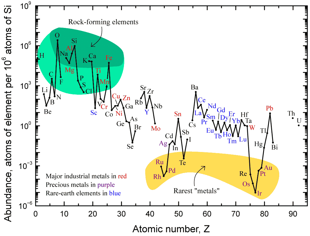 Fig. Abundance (atom fraction) of the chemical elements in Earth upper continental crust as a function of atomic number. The rarest elements in the crust (shown in yellow) are rare due to a combination of factors: all but one are the densest siderophiles (iron-loving) elements in the Goldschmidt classification, meaning they have a tendency to mix well with metallic iron, depleting them by being relocated deeper into the Earth core. Their abundance in meteoroids is higher. Tellurium has been depleted by preaccretional sorting in the nebula via formation of volatile hydrogen telluride.
 |
Palaeomagnetism or paleomagnetism (古地磁気学)Study on magnetic fields recorded in rocks, sediment or geophysial materialssupport the continental drift based on plate tectonics 1906 Brunhes, Bernard 1867-1910, France: discovered paleomagnetism
some rocks had magnetic properties that were the exact opposite as the Earth magnetic field → young rocks = straight polarity ↔ old rocks = reversed polarity ≥ 1950: reversed paleomagnetism supported by lava stratigraphy in Iceland |
≥ 1960: measurements of paleomagnetism for the past 4 Mya
in volcanic rocks worldwide, combined with K-Ar dating 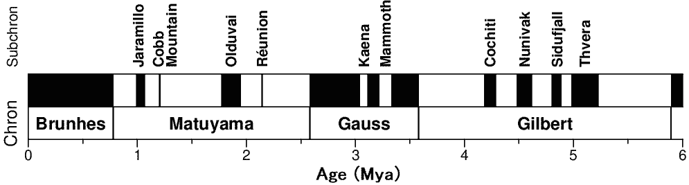 ↑ Matuyama–Brunhes polarity transition
Fig. Temporal changes in paleomagnetism for the last 6 million years (Gee & Kent 2007). Black and white indicate the direction is same with the present (straight polarity or normal) and not (reversed polarity or reverse), respectively. paleomagnetism reversal occurred a few hundreds of times - coded by number ≥ 1960: Vine–Matthews–Morley hypothesis
When geomagnetic reversal and seafloor spreading are assumed, oceanic stripe magnetic anomalies can be explained |
|
Classification by components: Shallow ⇐ earth crust (地殻), mantle (マントル). core (核) ⇒ deep Earth crust (or crust, 地殻)Oceanic crust: made of basaltlow silica and high in Fe and Mg - high density Continental crust: made of granitehigh Al and Mg silicate with quartz and feldspar - low density ⇒ Continents lie above sea leavel and oceanic crust lies below sea level due to the density differencesMantle (マントル)Core (核)Outer core (外核)Inner core (内核)Origin of sea (海の起源)Nowadays …Earth is suitable location to allow water to be in liquid state the ocean covers 71% of the earth surfae, containing 97% of the water on the earth
covers 61% of the northern hemisphere and 80% of the southern hemisphere |
Past … Big bang → galaxies and stars → solar system → the earth (core + mantle + crust) Probably the oceans formed as soon as the earth cooled enough for water to become liquid≈ 4 bya (∵ the oldest rocks = 3.8 bya) Outgassing (気体放出): oceans are byproducts of heating and differentiationwater locked in the minerals as hydrogen, as earth warmed and partially melted, and oxygen was released and carried to the surface by volcanic venting activity Sea salts: chemicals leached from the rocks in the crust + some volatile chemicals (hydrochloric acid and hydrogen sulfide) released from the earth interior by volcanic activitiesprobbly the ocean became salty soon after it formed. Salts have accumulated gradually due to weathering |