(Upload on April 29 2026) [ 日本語 | English ]
Mount Usu / Sarobetsu post-mined peatland
From left: Crater basin in 1986 and 2006. Cottongrass / Daylily
HOME > Lecture catalog / Research summary > Glossary > Forest
|
One of the biomes (バイオーム) that has a dense growth of trees, plants and underbrush covering a large area, but..., how dense? An ecosystem or assemblage of ecosystems dominated by trees and other woody vegetation, ... still, but how dominated? ⇒ physiognomy (相観) Defined by the US National Vegetation Classification SystemForest: consisting of trees with overlapping crowns forming 60-100% coverWoodland: opened with 25% to 60% cover Forest stand (林分)a contiguous tree community uniform in composition, structure, age, size, class, distribution, spatial arrangement, condition or location on a site to distinguish it from adjacent communities (forest science) |
[ mixed forest | Cascades | Alaska ] [ Jomon forest ] |
On the global scale, forest types are classifed by temperature and precipitation. However, classification systems are not unified.
| Tropical forest (熱帯林) | 4 | Boreal forest |
|---|---|---|
 The background of plantation for conducting agroforestry is a natural rainforest at Los Banos. Philippines. The dominant species are tall, evergreen broad-leaved trees. When precipitation decreases, the forest changes to seasonal forest. The background of plantation for conducting agroforestry is a natural rainforest at Los Banos. Philippines. The dominant species are tall, evergreen broad-leaved trees. When precipitation decreases, the forest changes to seasonal forest. |
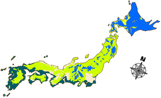
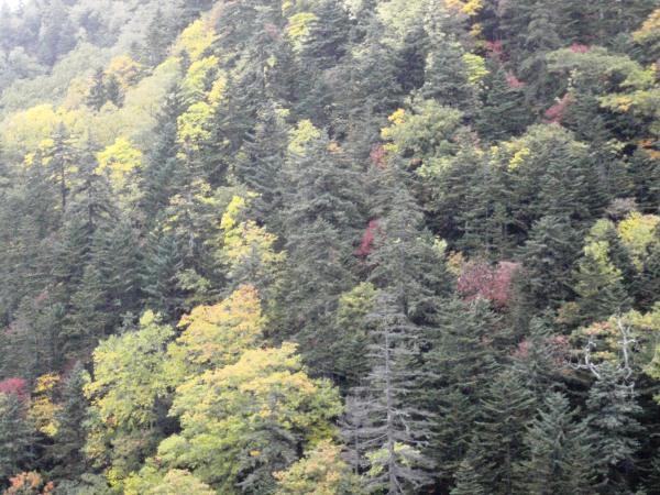
 It is often the same with deciduous (borad-leaved) forest. Check tree species in Hokkaido, Japan. In Hokkaido, mixed forest with evergreen needle-leaved and decidous broad-leaved trees is also found. It is often the same with deciduous (borad-leaved) forest. Check tree species in Hokkaido, Japan. In Hokkaido, mixed forest with evergreen needle-leaved and decidous broad-leaved trees is also found. |
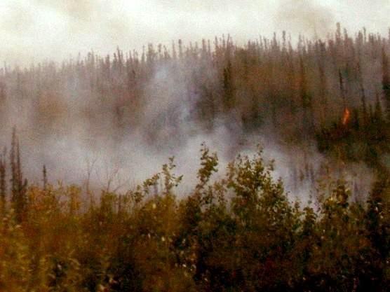 Boreal forest is taiga, or includes southerly part of taiga. Taiga is characterized by needle-leaved trees, such as Picea mariana in Alaska and Larix gmelinii in eastern Siberia. Permafrost is related to the distribution patterns of taiga. (Photo: a wildfire occurring in P. mariana forest) Boreal forest is taiga, or includes southerly part of taiga. Taiga is characterized by needle-leaved trees, such as Picea mariana in Alaska and Larix gmelinii in eastern Siberia. Permafrost is related to the distribution patterns of taiga. (Photo: a wildfire occurring in P. mariana forest) |
Tropical forest (熱帯林)Distribution of tropical forests in the worldPersebaran Kawasan Hutan Tropis di Dunia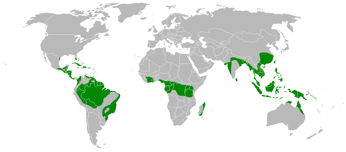
Subropical forestTemperate forestLaurentian mixed forest (ローレンシアン混交林)= North Woods (one of the forest ecoregions)temperate broadleaved and mixed forests biome transition zone between the boreal forest and the Big Woods and Carolinian forest
Conifers: pines, spruces, firs and junipers most of the region was covered by glaciers during the last ice age |
Boreal forest (冷温帯林)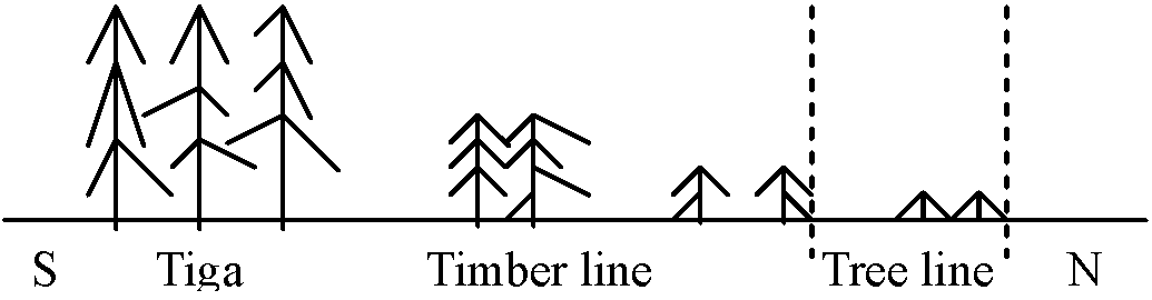 Fig. Vegetation change in Siberian taiga Timber line: boundary of forest and forest-less zones Tree line: boundary of tree and tree-less zones = similar with Japanese subalpine zone 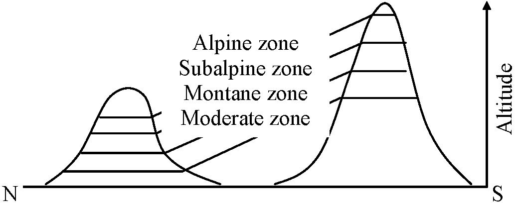 Altitudinal vegetation zonation patterns are similar with latitudinal patterns → the causes of differences in vegetation between them |
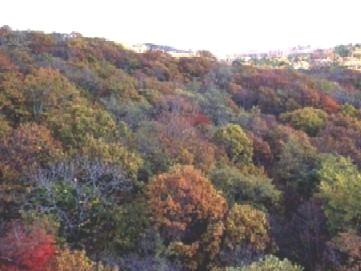
The forest develops tween temperate broad-leaved and subarctic needle-leaved forests.
| Forest zone | Boreal coniferous (taiga) | Boreonemoral-mixed | Nemoral-temperate summer green |
| Needle-leaved trees | Picea, Abies, Pinus, Tsuga, etc. | Picea, Abies, Pinus | |
| Broad-leaved trees | Quercus, Acer | Fagus, Acer, Quercus, Tilia |
 1
1
 2
2
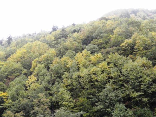
[1/2] between Jozankei and Nakayama Pass, Sapporo, on October 9 2010. The red and yellow leaves are from deciduous broad-leaved trees, and the green leaves are from evergreen needle-leaved trees.
|
artificial forest or man-made forest (人工林) natural forest (天然林): a forest composed primarily of indigenous species that have established and evolved without direct human planting the fowllowing four forest types are translated as genseirin (原生林)
old-growth forest (成熟林): mature forest with least human disturbance,characterized by large trees and layered canopy |
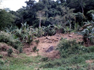
naturally-regenerated forest (天然生林): a forest that has recovered after disturbance (e.g., logging, fire and agriculture) through natural processes like seed dispersal or sprouting |
Wahington State [ plant species | wetland vegetation ]
|
Species are listed below first according to their general community (群集) affiliation and, within broad communities, by gross life-form (生活型). Ecological information is listed for these and other species on separate handouts. After each zone major associations found are listed, giving dominant species and general habitat conditions. Species marked by an asterisk are typical of the zone, usually dominant. x indicates general habitat conditions where the species is most likely to be found. Forest zoneswest of the Cascades |
These forests have no true counterpart in any other part of the world. Strong dominance by conifer species, longevity and productivity of dominants, highest biomass of any vegetation type. Climate is mild and precipitation is both high and concentrated in the winter. Catastrophic climatic events (fire, hurricanes) are infrequent, so that forests may attain their maximum genetic potential.
Picea sitchensis |
East of the CascadesPinus ponderosaPseudotsuga menziesii Abies grandis Abies lasiocarpa Lodgepole Pine ZoneMany very different situations lead to the hostile environments for plant growth which characterize the Lodgepole Pine Zone. This zone is not at all widespread, but it offers special problems. It is found in sites which are either very frosty year-around, very droughty and nutrient poor (such as the Kalama Mudflow and various recent lava flows) or very moist and cold (such as high elevation bogs). |
Sitka spruce (Picea sitchensis) forest zoneDistribution: narrow band of coastal forest, stretching from south-east Alaska to Northern California. Best developed in the major river valleys of the western Olympic Peninsula.Elevation range: usually below 150 m, but up to 600 m where mountains are close to the coast. Climate: fog common, abundant rain, over 300 cm/yr, less than 10% as snow; temperatures mild, frosts rare, summers cool, and range narrow. Soil: deep, rich organic soils developed primarily on flood plains, and young terraces; pH typically from 5.0 to 5.5. Table. Sitka spruce (Picea sitchensis) forest zone Life Species Wet Moist Dry Seral Comments form
Trees  Picea sitchensis*           x             Climax
       Tsuga heterophylla*         x             Climax
       Thuja plicata           x
       Pseudotsuga menziesii             x   x
       Pinus contorta                    x   x
       Alnus rubra             x             x   Riparian
       Acer macrophyllum       x                 Riparian
Shrubs Acer circinatum         x   x         x
       Oplopanax horridum*     x
       Gaultheria shallon*               x   x
       Vaccinium ovatum*                 x
       V. parviolium*                        x
       Sambucus racemosa                     x
       Rubus spectabilis*      x             x
Herbs  Polystichum munitum*        x     x
       Oxalis oregana*             x
       Blechnum spicant*       x   x
       Maianthemum dilatatum       x
       Montia sibirica             x         x   Disturbance
       Tiarella trifoliata         x
       Viola sempervirens          x
       V. glabella                 x
       Athyrium filix-femina*  x   x
       Cornus unalaschkensis   x	x
       Lysichitum americanum   x
       Carex obnupta           x
|
Typical associations: Picea sitchensis/Polystichum minitum/Oxalis oregana; Coastal: Tsuga heterophylla-P. sitchensis/Galtheria shallon-Vaccinium ovatum; Pinus contorta/G. shallon; Wetter sites: P. sitchensis-T. heterophylla/Oplopanax horridum-Athyrium filix-femina; Tsuja plicata/O. horridum/A. filix-femina; Seral: Acer circinatum/P. munitum; G. shallon/Vaccinium parvifolium. Dominant species: Picea sitchensis, Tsuga heterophylla, Thuja plicata, Pseudotsuga menziesii, Abies amabilis. Pinus contorta occurs along the coast and Alnus rubra occurs on disturbed sites and river flats. Acer macrophyllum is scattered along river valleys. Major subordinate species: Polystichum minitum, Oxalis oregana, Maianthemum dilatatum, Montia sibirica, Tiarella trifoliata, Viola sempervirens, V. glabella, Vaccinium parvifolium, and Menziesia ferruginea. Dry site subordinates: Gaultheria shallon, Rhododendron macrophyllum, and Vaccinium ovatum. Wet site subordinates: Oplopanax horridum, Athyrium filix-femina, Blechnum spicant, Dryopteris austriaca, and Sambucus racemosa. Succession: Dense shrub communities often dominate post-fire or logging succession. These include combinations of Rubus spectabilis, Sambucus racemosa, and Vaccinium species. Alnus rubra is most common tree dominant in seral stands. Special types:
|
This zone is moist and warm. It is ideal for the growth of trees. Dense stands of Douglas-fir invade following catastrophic wildfires. These stands include lesser amounts of red alder, western recedar, bigleaf maple and western hemlock. Without further disturbance the Douglas-fir is replaced by western hemlock after many centuries. This zone resonds most favorably to most management activities. It provides considerable quantities of timber and is of vital importance for many wildlife species and for high quality watersheds.
Distribution: This is widely distributed in lowland western Washington, below about 900 m, including Puget Sound and lower Cascades, Mt. Rainier, etc., grading into other zones at higher elevation.
Elevation range: near sea level to over 1000 m in western Washington; higher in drier areas, lower in wetter areas; snow depth accumulation may control upper distributional limit.
Climate: wet, mild, maritime climate with about 200 cm a typical amount; 10% falls during summer. Frosts common, with heavy snow at the higher elevations.
Soil: profiles deep, moderately acid, organic matter moderate to high, with deep litter common due to relatively slow decomposition; a variety of soil types including haplohumults (reddish brown laterites), dystrochrepts (brown podsols), and haplumbrepts (brown forest).
| Life form | Species | Wet | Moist | Dry | Seral | Comments |
|---|---|---|---|---|---|---|
| Trees | Tsuga heterophylla* | x | climax | |||
| Thuja plicata* | x | x | ||||
| Pseudotsuga menziesii* | x | x | ||||
| Abies grandis* | x | |||||
| Pinus monticola | x | x | bogs | |||
| Alnus rubra* | x | x | ||||
| Acer macrophyllum | x | |||||
| Populus trichocarpa | x | x | ||||
| Arbutus menziesii* | x | |||||
| Quercus garryana* | x | |||||
| Shrubs | Oplopanax horridum* | x | ||||
| Gaultheria shallon* | x | x | ||||
| Holodiscus discolor* | x | x | openings | |||
| Rubus spectabilis* | x | x | ||||
| Vaccinium ovatum* | x | |||||
| V. parvifolium* | x | x | ||||
| Linnaea borealis | x | x | ||||
| Oemleria cerasiformis | x | |||||
| Rhamnus purshiana | x | |||||
| Rhododendron macrophyllum | x | x | ||||
| Vaccinium alaskense | x | |||||
| Taxus brevifolia | x | |||||
| Herbs | Achyls triphylla* | x | ||||
| Athyrium filix-femina* | x | x | ||||
| Blechnum spicant | x | x | ||||
| Clintonia uniflora | x | |||||
| Epilobium angustifolium | x | fire | ||||
| Lysichitum americanum* | x | |||||
| Polystichum munitum* | x | |||||
| Pteridium aquilinum | x | x | overgrazed | |||
| Trifolium ovatum | x | |||||
| Xerophyllum tenax | x | x |
(plus those of Sitka Spruce Zone)
Typical associations
Wet: Tsuga heterophylla(TSHE) / Lysichitum americanum; TSHE / Athyrium filix-femina; TSHE / Oplopanax horridum / Polystichum munitum.
Mesic: Lower elevation: TSHE/Polystichum munitum; TSHE/Berberis nervosa-Gautheria; TSHE/Achyls triphylla. Drier: TSHE/Gaultheria shallon; TSHE/Cornus unalaschkensis-Achyls triphylla. Xeric: TSHE - Pseudotsuga menziesii/Holodiscus discolor; (TSHE)-Pseudotsuga menziesii - Arbutus menziesii; Abies grandis/Achyls triphylla; Quercus garryana (several associations). Higher elevations: TSHE/Vaccinium alaskense-Cornus; TSHE/ Vaccinium alaskense-Gaultheria.
Major subordinate species: Holodiscus discolor, Vaccinium parvifolium, Berberis nervosa, Gaultheria shallon, Polystichum munitum, Xerophyllum tenax, Athyrium filix-femina and many others.
Dry site subordinates: Berberis nervosa, Gaultheria shallon, Linnaea borealis.
Wet site subordinates: Oplopanax horridum, Athyrium filix-femina, Blechnum spicant, Viola glabella, Achlys triphylla, Lysichitum americanum.
Typical associations along a gradient from wet to dry: Thuja plicata/Tsuga hetterophylla/Oplopanax horridum/Athyrium filix-femina Thuja plicata/Acer circinatum/mixed herbs Tsuga heterophylla/Polystichum munitum/mixed herbs Pseudotsuga menziesii/Gaultheria shallon Pseudotsuga menziesii/Rhododendron macrophyllum
Succession: Invaders of clear cuts: Epilobium angustifolium, Cirsium vulgare, and Pteridium aquilinum; followed by shrub stage with Rubus ursinus, Acer circinatum, and Gaultheria shallon typical. Alnus rubra is most common natural invader, slowly replaced by conifer species, primarily Pseudotsuga menziesii.
Sepcial types: Edaphic prairies (e.g., Mima Mounds, Ebey's Prairie) in which forest never developed due to poor soil conditions and fire. Soils are glacial drifts with coarse texture, poor nutrient status, and well drained. Talus communities occur on steep slopes with unstable substrates. Acer circinatum usually dominates with many shrub species and the more xerophytic herbs and fern species.
Persistent winter snow packs help delimit this zone. It spans the gradient between the warm, moist Western Hemlock Zone and the very cold, moist Mountain Hemlock Zone. The forests are dominated by Douglas-fir and noble fir following large fires, but these species are eventually replaced by Pacific silver fir. This zone provides high values of many resources, but the prevailing cold climates dictate the type of management activities.
Distribution: Mid-montane slopes of Olympics and Cascades from Central BC to Oregon; requires moderate to heavy snow and mild summer temperatures.
Elevation: Usually between 600 and 1400 m; strongly influenced by topography, aspect, and snowpack.
Climate: Compared to Tsuga heterophylla zone, a much greater fraction of precipitation occurs as snow, up to 40%. At Snoqualmie Pass, annual precip. is 2600 mm, with less than 10% falling June to August. Winter snow packs are moderate, from one to three m, and temperatures are cool, with maximum summer temperature only 21°C.
Soil: Typically cryothods (podzols) with fairly thick litter accumulations; leached; acid.
| Life form | Species | Wet | Moist | Dry | Seral | Comments |
|---|---|---|---|---|---|---|
| Trees | Abies amabilis* | x | x | |||
| Tsuga heterophylla | x | lower slopes | ||||
| Abies procera | x | x | x | seral | ||
| Pseudotsuga menziesii | x | x | x | fire | ||
| Pinus monticola | x | |||||
| Tsuga mertensiana | x | x | higher slopes | |||
| Chamaecyparis nootkatensis | x | x | higher | |||
| Shrubs | Vaccinium alaskense* | x | x | |||
| V. membranaceus | x | |||||
| Menziesia ferruginea | x | |||||
| Rhododendron albiflorum | x | |||||
| Gaultheria shallon* | x | x | ||||
| Linnaea borealis* | x | x | x | |||
| Oplopanax horridum* | x | |||||
| Herbs | Blechnum spicant | x | x | |||
| Clintonia uniflora | x | |||||
| Cornus unalaschkensis | x | x | ||||
| Maianthemum dilatatum | x | |||||
| Pyrola spp. | x | |||||
| Rubus lasiococcus | x | |||||
| Streptopus spp. | x | |||||
| Xerophyllum tenax | x | x |
Typical association along a gradient from wet to dry:
Wet, low: Abies amabilis(ABAM) / Oplopanax horridum;
Wet, higher: ABAM / Rhododendron albiflorum;
Mesic, lower: ABAM / V. alaskense; ABAM / Gaultheria shallon; ABAM / Berberis nerbosa;
Mesic, higher: ABAM/Tiarella unifoliata; ABAM/Achyls triphylla-Clintonia uniflora; ABAM / V. alaskense/Clintonia uniflora;
Higher, dry: ABAM / Vaccinium membranaceum / Xerophyllum tenax
Major subordinate species: many ericades including Vaccinium spp., Menziesia ferruginea, Gaultheria spp., Chimaphila spp., Rhododendron albiflorum, and Pyrola spp. Xerophyllum tenax, Rubus lasiococcus, Cornus canadensis, and Clintonia uniflora common.
Succession: disturbed sites invaded by Pseudotsuga or A. procera, which will not regenerate under canopy conditions. Abies amabilis is usually late to invade, coming in under a mixed conifer canopy.
Special types: Alnus sinuata avalanche track vegetation; mesic meadows dominated by Pteridium aquilinum, resulting from moisture seeps or due to shallow or unstable soil.
The following key was designed as an aid in identifying the upper elevation associations of the Gifford Pinchot National Forest and vicinity. Environmental and management information applicable to a given site is accessed by identifying the association using the key, then referring to the detailed association description. The step in using the key are:
It is important to follow these steps rigorously since misidentification may lead to the wrong management considerations.The key is designed to be used in sequence. Always start at the beginning of the key and work systematically through.
The associations described in this guide are based on plot data collected throughout the forest and represent conceptual abstractions.In practice, few stands will conform exactly to the typical association description. Because vegetation varies continuously over the landscape, ecotones of transitional composition, which do not fit neatly into any described association, will be encountered. Such ecotones should be managed according to the characteristics of the associations between which they fall. In most cases, adjacent associations have similar management properties.There are about 50 common herb and shrub species used in the key and association descriptions.
Ecoclass
If not, it is ABAM/VAAL association CF S2-57
* stand condition at age 300 or more
Topik C, Halverson NM, Brockway DG. 1986. Plant association and management guide for the western hemlock zone. ![]() Pacific Northwest Region, USDA Forest Service
Pacific Northwest Region, USDA Forest Service
Mountain Hemlock (Tsuga mertensiana) forest zoneThe harsh, high elevations include this zone. Most of the year snow-packs prevail and frost can occur at any time of the year. The forest canopy provides a generally a continuous cover. Biological processes are slow and result in fragile ecosystems. The proximity to spectacular alpine areas and the relatively open understory characteristics of the forests make this zone a favorite for many recreations.Distribution: Forms timberline and forest/meadow complex in moist to wet mountains of Olympics and Cascades; primarily west of Cascade Crest. Climate: Cold, wet, with heavy snow pack. At Paradise, over half the annual precip. of 2700 mm occurs as snow, with less than 10% falling during summer. Elevation: This is the highest forest zone in western Washington, ranging form about 1300 to 1900 m, depending on latitude and local factors (topography and aspect). Soil: poorly developed podzols and gleys (hydric soils). Typical associations: On typical sites: Tsuga mertensiana (TSME)-Abies amabilis/Vaccinium membranaceum; higher elevations: Chamaecyparis nootkatensis-TSME/Rhododendron albiflorum-Vaccinium spp.; TSME/ Rhododendron albiflorum; |
moist, lower elevations: A. amabilis-TSME/V. alaskense; mesic, lower elevations: TSME/V. alaskense. Table. Mountain Hemlock (Tsuga mertensiana) forest zone (Klinka weighted average method)
Lifeform Species Wet Moist Dry Seral Comments
Trees Tsuga mertensiana x x Abies amabilis* x x lower slopes Abies lasiocarpa* x x Pinus contorta x x Chamaecyparis nootkatensis x x higher slopes Shrubs Vaccinium membranaceus* x x x fire tolerant Vaccinium alaskense x Rhododendron albiflorum* x x Phyllodoce empetriformis x x Herbs Erythronium montanum x Pyrola secunda x Rubus lasiococcus x Valeriana sitchensis x Veratrum viride x x Xerophyllum tenax* x x |
Ponderosa Pine (Pinus ponderosa) forest zoneDistribution: common at the lower timberline along the eastern base of the Cascades, and in the Okanogan highlands and higher elevations surrounding the Columbia basin. Elevations range from about 500 m to 900 m.Climate: low precipitation, only 50 to 60 cm/yr, with little snow and pronounced summer droughts. Temperature range is great. Soil: moderately acid with low organic content but thick litter due to slow decomposition rates. Table. Ponderosa Pine (Pinus ponderosa) forest zone. (a) see also Douglas Fir Zone, below
Lifeform/Species Wet Moist Dry Seral Subordinate species: highly variable due to locate. Symphoricarpos albus, Festuca idahoensis, Agrophyron spicatum and Purshia tridentata are dominate in large areas. Succession: fire is a major component of the ecosystem. P. ponderosa is fire resistant and repeated, mild fires scar, but no not destroy adults. Fires kill invading small trees of other conifers and prevent succession. Fire also enhances grasses at the expense of shrubs. Ceanothus velutinus (a symbiotic nitrogen-fixing species) invades after hot fires. Special type: Areas of special soil (e.g., serpentine) may support stable populations of Pinus contorta and a limited array of drought tolerant herbs and shrubs. Douglas fir (Pseudotsuga menziesii) forest zoneThis zone is widely distributed throughout the western US. In contrast to west-side forests, here Pseudotsuga is truly a climax species.Distribution: widely distributed in western US, found above Ponderosa Pine forest; here Douglas fir is true climax species. Overlapping with other forest types in response to topography and disturbance. Elevation: Typical range in central Washington is from 600 to 1300 m, overlapping with P. ponderosa in mesic sites at the low end and with Abies grandis on xeric sits at the high end. Climate: slightly cooler and more moist than Ponderosa Pine zone, with precipitation about 100 cm/yr, scant summer rain, and greater snow pack. Soil: slightly podzolic, more leached than soils of Ponderosa Pine zone, tending more towards Haplorthods (gray wooded soils, with podzolic tendencies) Table. Douglas fir (Pseudotsuga menziesii) forest zone. Identifying seral species is challenging. Lupinus polyphyllus establishes in open sites.
Lifeform/species Wet Moist Dry Subordinate species: similar to those of drier Tsuga heterophylla zone, plus Agrophyron spicatum, Carex geyeri, Arctostaphylos nevadensis, Arnica spp. and many others. Succession: fire controls major distribution; P. menziesii will dominate in stable stands, but any of the trees listed above may dominate if fires have been recent. Grand fir (Abies grandis) forest zoneThis zone reflects dry, continental climates with extremes in temperature and moisture. It is highly productive and offers many opportunities for wildlife, recreation and timber utilization.The relatively dry climates dictate different management strategies than in the Western Cascade areas under the maritime climatic influence.Distribution: restricted in Washington, found in the eastern Cascades sandwiched between Douglas fir forests in direr, lower sites and subalpine fir or western hemlock forests in moister, higher sites. Elevation: Abies grandis is dominant from 1000 to 1200 m in mesic habitats, the central Cascades. Climate: Moderate in moisture and temperature; limited summer drought. Summer drought ameliorated by protected aspects and occurrence in riparian setting. |
Soil: Poorly developed, but deep in most places due to volcanic ash accumulations. They are podzolic, primarily in the Haplorthods and Haplubrets groups. They are slightly acidic and have moderate organic matter. Typical associations: Abies grandis (ABGR)-Tsuga plicata/Acer glabrum/Clintonia uniflora; ABGR/Pachistima myrsinites; ABGR/Vaccinium membranaceum; ABGR/Pyrola sp. Subordinate: Pachistima myrsinites, Vaccinium membranaceum, Rosa gymnocarpa, and Ribes lacustre. are common shrubs, while mesophytic herbs such as Arnica cordifolia, Galium triflorum, Arenaria macrophylla, Linnaea borealis, Aenocaulon bicolor, and Trillium ovatum are common. Succession: Ceanothus velutinus is a major brushfield dominant after fire. Many seral tree species actually grow better in this zone than where they are climax, but A. grandis can shade them out. Table. Grand fir (Abies grandis) forest zone
Life form/Species Wet Moist Dry Seral Comments Subalpine fir (Abies lasiocarpa) forest zoneDistribution: Near timberline in direr timberline sites; NE Olympics, the Okanogans, drier eastern Cascades (including Mt. Rainier) and Wenatchee Mountains.Elevation: The lower limit is usually below 1400 (1500) m, extending to local treeline (2000 m asl). It abuts Abies grandis zone forest in mesic sites, Pseudotsuga zone forests on xeric sites, and many contact Tsuga heterophylla zone in some places. Climate: (Climatic data are scarce) Cool and moist with moderate snow packs (locally heavy), but some drought; growing season relatively short with summer maxima under 15°C. Soils: Generally cryothods (podozols with thin humus layers). Very acid due to low temperatures and slow decomposition of humus. Typical associations: Abies lasiocarpa (ABLA)/Pachistima myrsinites/Clintonia uniflora; ABLA/Menziesia ferruginea; ABLA/Phyllodoce empetriformis; ABLA/Vaccinium scoparium-Juniperus communis; Pinus albicaulis (PIAL)-ABLA/Arctostaphylos-Pachistima; ABLA-Picea engelmannii/Vaccinium membranaceum; ABLA-Larix lyallii/Phyllodoce-Vaccinium. Subordinate species: Pachistima myrsinities, Clintonia uniflora, Viola glabella, Adenocaulon bicolor, Arenaria macrophylla, and many other mesophytes. Ericads dominate in the wetter portions, graminoids in more open, upper areas. Succession: Pinus contorta is the major seral tree, though Picea is usually seral as well. Closed forests in this zone will generate into monospecific crown dominate by A. lasiocarpa; upper, open forests will be more complex. Special type: A weakly developed A. lasiocarpa zone forest can be recognized in the North Eastern Olympics at timberline between Hurricane Ridge and the Blue Mountain areas.
Typical associations: Abies lasiocarpa (ABLA)/Pachistima myrsinites/Clintonia uniflora; ABLA/Menziesia ferruginea; ABLA/Phyllodoce empetriformis; ABLA/Vaccinium scoparium-Juniperus communis; Pinus albicaulis (PIAL)-ABLA/Arctostaphylos-Pachistima; ABLA-Picea engelmannii/Vaccinium membranaceum; ABLA-Larix lyallii/Phyllodoce-Vaccinium.
Life form/Species
Wet
Moist
Dry
Seral
Comments |
Taking notes on July 30 2014
... and the Forest EndsJust as there is a northern tree limit on the earth, there is also an upper tree limit on mountains -- sometimes called "timberline." Whether it's latitude or altitude, tree limit is determined by the same factors: length of the growing season, combined with temperature and wind.
↑ You are here (northern edge of Brooks Range, Alaska): 777 m - elevation of timberline |
Limits for differnt trees along the Dalton Highway
white spruce limit - you are here |
|
≡ the planned human intervention in forest ecosystems to achieve specific environmental, economic and social objectives
including administrative, legal, scientific and technical activities such as silviculture, forest protection, timber harvesting, conservation and land-use planning 2021 National Forest Management Plan of Japan
→ comprehensive forest management |
Def. Mother tree, seed tree or seed source tree (母樹): a selected parent tree used specifically for producing seeds
genetically superior or otherwise desirable individual |
|
≈ conservation forest, ecological forest Environmental‑function forests are expanding globally Drivers: climate mitigation, biodiversity conservation, disaster prevention, water security and urban environmental improvement Note: the concept is different between countries ☛ Japan (日本) Europe (EU): ecosystem restoration and protective forests
EU Biodiversity Strategy 2030
Three‑North Shelterbelt Program, Grain for Green Program, Ecological Public‑Benefit Forests |
USA
riparian forests → water quality + habitat protection
Ex. urban greenbelt forest, urban environmental forest
windbreak forests → farmland protection
Brazil: Amazon restoration, riparian buffer forests |