(Upload on July 17 2021) [ 日本語 | English ]
Mount Usu / Sarobetsu post-mined peatland
From left: Crater basin in 1986 and 2006. Cottongrass / Daylily
HOME > Lecture catalog / Research summary > Glossary > Japan
[Vertical distribution of vegetation]
|
Table. The specificity of soil and/or topography in Japan (Usui 1971). Vegetation Cryptomeria Pinus densiflora- japonica Rhododendron kaempferi plantaion subassociation Chamaecyparis in a valley Carex lanceolata obtusa plantation Plots 6 10 4 Chemical Soil component layer N (%) A0 1.37 1.02-1.48 0.73-1.23 A 0.28-0.95 0.24-0.66 0.33-0.78 B 0.19-0.52 0.10-0.30 0.12-0.38 C (%) A0 - 10 - A 5-13 2-11 3-13 B 3-7 1-9 1-8 Ca A0 285-388 202 116-191 (mg/100 g) A 10-279 3-150 13-27 B 3-7 1-93 1-10 pH A0 - 3.9-4.0 3.6-4.4 A 4.4-5.2 4.0-4.8 3.8-4.7 B 4.4-5.8 4.2-5.0 4.2-5.0 Pinus densifolia = valley, Rhododendron kaempferi = convex surface (secondary forest), Chamaecyparis obtusa = depleted ridge |
|
[Hokkaido(北海道), Sapporo (札幌), vertical distribution, forest (森林)]
|
(Yamanaka 1990) |
Warmth index: 85 < laurel forest (evergreen broad-leaved forest) 45-85: deciduous broad-leaved forest 15-45: evergreen needle-leaved forest (subalpine zone) 15 > alpine zone |
Needle-leaved forest (常緑針葉樹林)
Larix + |
Regeneration on fallen logs (倒木更新)= regeneration on nurse logs (one of the gap dynamics)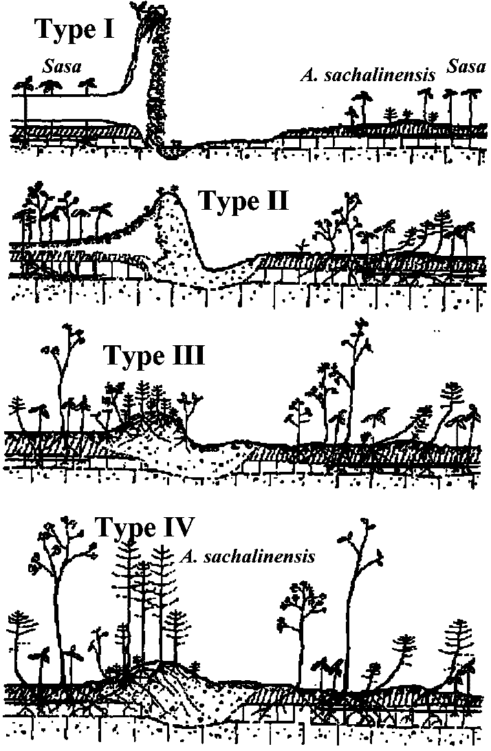 Type I: Uprooting tee Type II: Seed immigration on the mound. The height of uproot is decreased by decay and erosion Type III: Stable uprooted mound Type IV: Development of suceeding trees of Sakhallin fir (Abies sachalinensis Fr. Schm.) Fig. Tree regeneration on nurse tree in Nopporo |
The imperial gardens in the former lawn Shiba detached palaceKyu shiba rikyu onshi teien (旧芝離宮恩賜庭園), Tokyo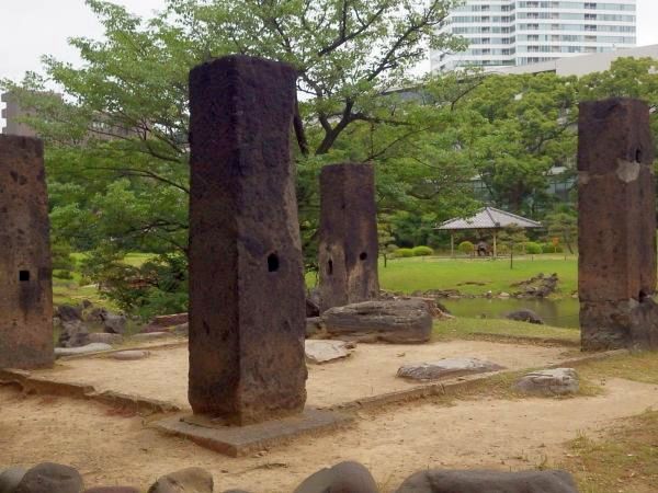 Stone Piller
This stone pillar is a gatepost that was transported from the former residence of a warlord who served the Odawara Hojo clan during the Warring States Period. The area is said to have been the site of a tearoom when it was the main Tokyo mansion of the Odawara Domain (Okubo clan). 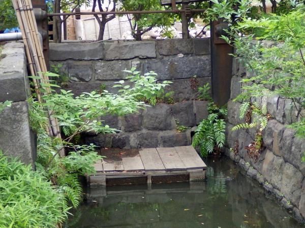 Remains of Seawater Intake
This channel was built to take in seawater for the tidal pond. The remains of the channel's stone walls and steel sluice gate can still be seen. At present, te pond has been cut off from the sea and is now a freshwater pond. 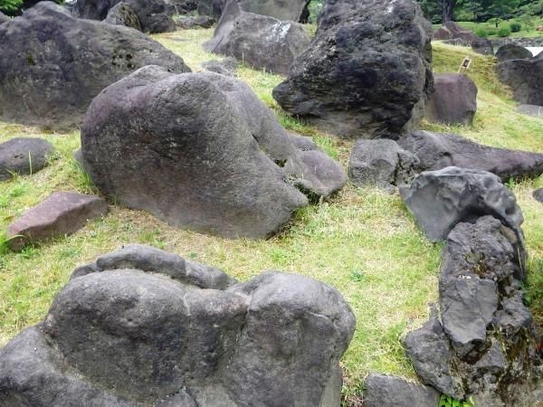 Nakajima
The arrangement of stones on this island represents Mt. Horai (Chinese Mt. Penlai), a sacred mountain in Chinese mythology that is said to be the land where the immortals live, and where there is no death or old age. 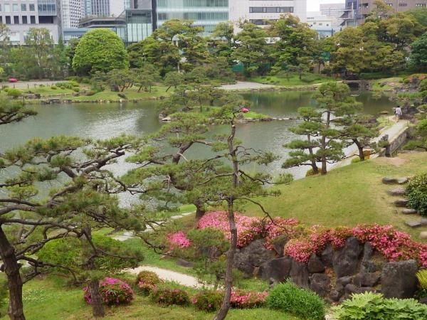 Seiko-no-Tsutsumi (West Lake Embankment)
West Lake (Japanese: Seiko) is a lake in Chinese city of Hangzhou in Zhejiang Province, famed for its scenic beauty. The poet Su Dongpo (Su Shi) had a long causeway built in the lake during the Northern Song Dynasty. This embankment is a replication of that causeway. Similar structures can also be seen in Koishikawa Korakuen Garden and in Hiroshima's Shukkei-en Garden. (May 29 2015) Koishikawa Korakuen GardensKoishikawa Korakuen (小石川後楽園), TokyoA deep ravine still remains in 0-edo (Tokyo) In the early Edo Period, in 1629, the founder of the Mito Tokugawa family, Yorifusa, maintained a separate Edo residence, the garden of which was completed during the reign of the second clan ruler, Mitsukuni. This garden features a central pond and hills, making it perfuct for a stroll. When Mitsukuni set about constructing the garden, he incorporated some concepts of the Chinese Confucian scholar Shushunsui of the Ming dynasty. including a garden reproduction of Seiko Lake (China), a "Full Moon Bridge" and other features with culrural origins in China. The name of the garden, "Korakuen" came from a Chinese text in Hanchuen's "Gakuyoro-ki" admired by Mitsukuni which said that there is "a need for those in power to worry about maintaining power first and then enjoy power lattr." Thus, the name Korakuen, meaning "the garden for enjoying power later on," was chosen. Under the terms of the Law for Preservation of Cultural Assets, Koishikawa Korakuen has been desinuated an important historical asset and site of special historical significance. This double designation has been given only to such important sites as Koishikawa Koraken, Hama Detached Palace, Kinkakuju, etc. |
• Hitotsu-matsu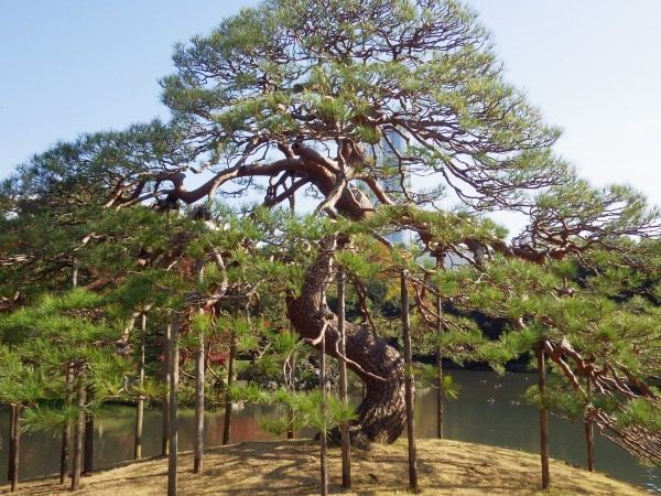 While the big pond was interpreted as Lake Biwa, the biggest lake in Japan, this landmark was called Hitotsumatsu after the one stnding on the coast of the lake.
• Tokujin-do This is the oldest building in the garden. Mitsukuni, the 2nd lord of Mito-Tokugawa family, ordered it to niche the two statues of Hakui and Shukusei. Mitsukuni, an earnest of Confucianist, deeply impressed by their lives. The name of this small shrine is derived from the Analects of Confucious. 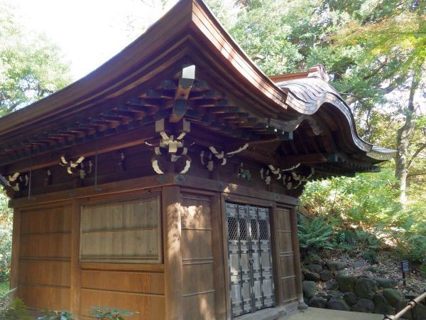 • Hakke-do traces
When Mitsukuni, the 2nd loar of Mito-Tokugawa family, met the 3rd shogun, Iemitsu, he was given a statue of a patron saint of literature. Later he built a small shrine called Hakke-do to enshrine the statue in. The shrine was burnt down in the big fire after a great earthquake in 1923. • Komachi-zuka The producing district of this stonewas Ono in Hitachi area. Mitsukuni, the 2nd lord of Mito-Tokugawa family, connected Ono with Ono-no-Komachi, a famous beauty in old times and called. This stone was quarried in Ono. • Montument (Mr. Touko Fujita) • Kisoyama This mountain is called Kisoyama, as old trees shading sunlight and a winding road along a mountain stream reminded people Kiso Highway, one of the main highways to Kyoto. It is also called shuro-yama, or palm trees mountain, because there are a lot of palm trees. (November 18 2016) 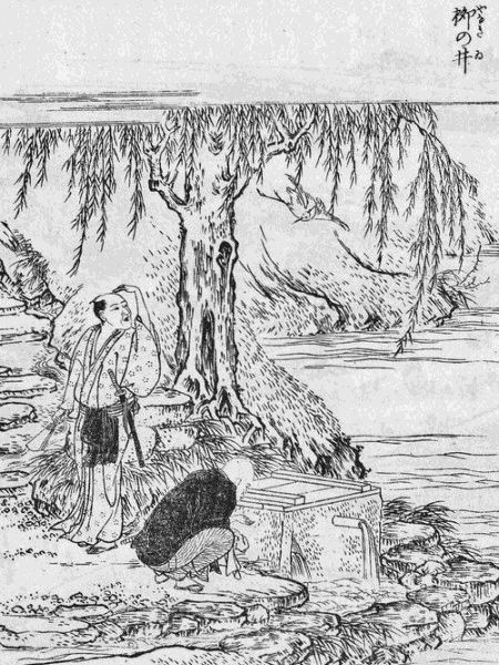
Yanagi (Willow Tree) Well (柳の井)Designated Historic Site, Tokyo Metropolis____Designated March 28, 1955This well below the embankment of Sakurada-bori Moat is known as the Well of Yanagi due to the willow tree (yanagi) nearby. During the Edo Period (1603-1868), it was known as a famous water source that never dried up, even during times of drought, and it is said that it was used by many of the people who passed by. In the National Diet Building Garden (formerly the residence of Kato Kiyomasa and Ii Kamonnokami) across the road, is the Sakura (Cehrry Tree) Well, also well known as a famous water source. Kanda-Sakumacho 3-chome (神田佐久間町三丁目)This neighborhood, which was inhabited by a mixture of samurai and merchants, takes its name from Heihachi Sakuma, the inherited name given to head of a lumber merchant family that lived in this area from generation to generation.Osaka Castle Park (大阪城公園)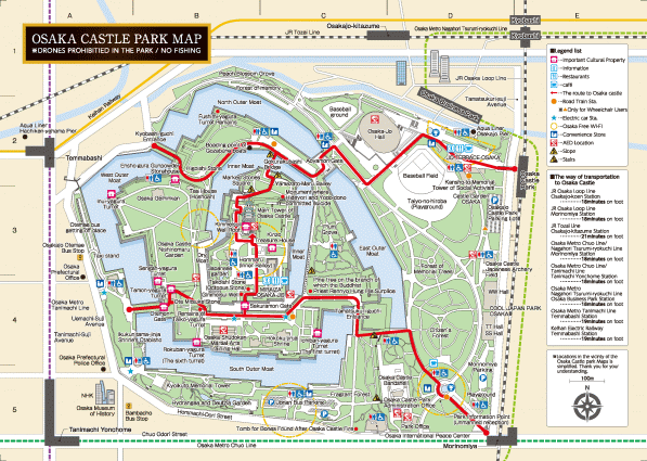
Ichi-no-kami-kuruwa Bailey (市正曲輪)Around the early 17th century when Hideyori was a lord of the castle, Katsumoto Katagiri, one of the Toyotomi's guardians, lived around this vicinity. Katsumoto's official title was "Higashi-ichi-no-kami" and the place was called "Ichi-no-kami-kuruwa". In the Edo period an office for "Kaban" guards of the castle was established in this area. Presently many apricot trees have been planted here.Remains of the Osaka Army Arsenal (大阪砲兵工廠跡)The Osaka Army Arsenal was one of the largest military factories in modern Japan, originating from the Zoheishi (Office of Weapons Manufacturing) established in 1870 in the vicinity of this site. Mainly producing cannons, as well as consumer gods, the Arsenal spearheaded the industrialization of Osaka. Its premises contain the areas presently known as Osaka Business Park, Morinomiya, and the east side of the Osaka Loop Line. The Arsenal was destroyed in 1945 air raids, and the former main building, which survived the bombing, was dismantled by Osaka City in 1981 to build Osaka-Jo Hall. In the Edo period, this area was called “Okura Kuruwa” (warehouse compound), where rows of warehouses to store rice collected as taxes and found. |
Region in Japan (地域)This is a typical classification, but it's not definitiveHokkaido (北海道)Tohoku (東北)Northern Tohoku (北東北): Aomori (青森), Iwate (岩手), Akita (秋田)Southern Tohoku (南東北): Miyagi (宮城), Yamagata (山形), Fukushima (福島) Kanto (関東)Northern Kanto (北関東): Ibaragi (茨城), Tochigi (栃木), Gunma (群馬)Southern Kanto (南関東): Saitama (埼玉), Chiba (千葉), Tokyo (東京), Kanagawa (神奈川) (classifications vary significantly among researchers) Chubu (中部)Ko-shinetsu (甲信越): Yamanashi (山梨), Nagano (長野), Niigata (新潟)Hokuriku (北陸): Toyama 富山, Ishikawa (石川), Fukui (福井) Tokai (東海): Shizuoka (静岡), Aichi (愛知), Gifu (岐阜), Mie (三重) |
Kinki (近畿)Shiga (滋賀), Kyoto (京都), Osaka (大阪), Hyogo (兵庫), Nara (奈良), Wakayama (和歌山)Chugoku (中国)San-in (山陰): Tottori (鳥取), Shimane (島根)San-yo (山陽): Okayama (岡山), Hiroshima (広島), Yamaguchi (山口) Shikoku (四国)Northern Shikoku (北四国): Kagawa (香川), Ehime (愛媛)Southern Shikoku (南四国): Tokushima (徳島), Kochi (高知) Kyushu (九州)Nortehrn Kyushu (北九州): Fukuoka (福岡), Saga (佐賀), Nagasaki (長崎), Kumamoto (熊本), Oita (大分)Southern Kyushu (南九州): Miyazaki (宮崎), Kagoshima (鹿児島) Ryukyu (琉球): Okinawa (沖縄) ☛ Biogeography (生物地理) |
| Kansai (関西) |
|
|---|---|
Hyakkenzan-keikoku Valley Trakking Map百間山渓谷トレッキングマップHyakkenzan-keikoku Valley is located at the base of the southwest slope of the 999-m-high Mount Hyakkenzan. Along the 3-km-long valley covered with primeval forests, there is an array of uniquely shaped rocks, potholes, and waterfalls of various sizes. In the valley, visitors can see a wide variety of wild plants and enjoy fantastic views of waterfalls and pools contrasting these plants. The beauty of the valley surrounded by nature makes a pleasant impression on visitors and heals their hearts.Ichimai-iwa Monolith of Koza-gawa River (古座川の一枚岩)Rock formed from magma that cooled beneath earth was uplifted and then eroded by river flow, leaving the vast wall of the monolith. That igneous rock extends more than 20 km eastward from the monolith as the Kozagawa arcuate dike, crescent-shaped remnant of the Kumano caldera that existed 14 million years ago. Monolith guard dog / A shadow that strikes the rock face gave rise to a folktale about a dog that guards the monolith.Utsugi stone, a time-honored resource / The rock of the monolith is relatively soft and easy to cut. For centuries it was used and called Utsugi stone, from the name of the local quarry. Kushima island and Suzushima island (孔島・鈴島)Yoshino-Kumano National Park Nanki Kumano Geopark Island blesses with an abundance of rare plants and animalsTreasury of seaside plants which thrive in a warm climate Kushima and Suzushima islands, with more than 120 vascular plant species, are treasuries of seaside flora adopted to a warm climate. The climate of two islands is influenced by the 'Kuroshio Current'. |
Ocean ← Coastal plants → Kushima Inland Styan's Grasshopper Warber, which is rare all over the world, migrates to the Kii Peninsula coast for breeding in summer. A small island, such as Kushima, is an important breeding place for the bird to avoid natural enemies. Hashigui-iwa Rock (橋杭岩)The mysterious landscape formed by magmaFormation of Hashigui-iwa Rock
Look for traces of magma entering the mudstone At the base of Hashigui-iwa, you can see traces of igneous rocks entering the mudstone The scattered stones on the coast are the debris of Hashigui-iwa Rock which were carried away by tsunami |
| Kyushu (九州) | |
"Manai Waterfall" of Takachiho Gorge (真名井の滝)Formed by the erosion of lava flows from ancient eruptions of Mount Aso, Takachiho Gorge offers stunning natural beauty. Its main attraction is the Manai Falls, one of Japan's Top 100 Waterfalls. For an unforgettable experience, take a boat ride and marvel at the waterfall up close. Additionally, you can enjoy the scenic beauty of Tamadare Falls, the powerful Onibaba Power Stone, and the iconic Takachiho Three Great Bridges. (2024/12/19) |