(Upload on September 26 2024) [ 日本語 | English ]
Mount Usu / Sarobetsu post-mined peatland
From left: Crater basin in 1986 and 2006. Cottongrass / Daylily
HOME > Lecture catalog / Research summary > Glossary > Geography
[Japan, Hokkaido] [geomorphology · geoecology]
|
Human geography (人文地理学): a branch of the social sciences related to the world, its people, communities and cultures
economic geography
geomorphology |
|
|
Symbolic depiction highlighting relationships between elements of some space, such as objects, regions, and themes.
[ natural science ] History of mapThales (BC624-BC526): BC5c gnomonic or central projection (心射図法)Eratosthenes (BC275-BC194), Ancient Greek
measured the circumference of the earth orthographic projection (正射図法) Hipparchos (BC190?-BC125?), Ancient Greek: BC late-2Cstereographic projection (平射図法) ⇒ applied to sundial, star chart, etc.Marinus of Tyre (70?-130?), Greek? equirectangular projection (正距円筒図法) The Age of Navigation (16th-17th Century) - need (world) mapsStab, Johann (Stabius, Johannes, 1460―1522, Austria) Werner, Johannes (1468-1522, Germany) → Stab-Werner projection Apian, Peter (Bienewitz, 1495-1552)
1530 used Stab-Werner projection for world map 1531 used Stab-Werner projection for (semi-)world map applied by Mercator (1538) |
Mercator, Gerhardus (1512-1594) Flemish (Belgium) geographer and cartographer Mercator projection (1569) Nova et Aucta Orbis Terrae Descriptio ad Usum Navigantium Emendate Accommodata a cylindrical map projection → standard map for navigation
Wright, Edward (1558-1615): showing the drawing by the projection published atlas "Theatrum Orbis Terrarum" (1570) Cossin, Jean (France): used Sanson projection (1570)Sanson, Nicholas (1600―1667, France): used this projection (1650) Bonne, Rigobert (1727-1795): Bonne projectionDe l'Isle, Joseph Nicolas (1688-1768) Mollweide, Karl Brandon (1774-1825): Mollweide projection (1805) von Hammer, Ernst (1858-1925): Hammer projection (1892) Eckert, Max (1868-1938): Eckert projection (1906) Winkel, Oswald (1873-1953): Winkel projection (1921) Goode, John Paul (1862-1932): homolosine projection and Goode projection (1923) Miller, Osborn Maitland (1897-1979): Miller projection (1942)Robinson, Arthur H. (1915-2004): Robinson projection (1974) late 20th c (developing computer and satellite technology) Colvocoresses, Alden P. (1918-2007)
(universal) oblique Mercator projection (1974) |
Mercator projection (メルカトル図法)1569 proposed by Mercator
cylindrical map projection |
Mollweide projection (モルワイデ投影図法)= Babinet projection, homalographic projection, homolographic projection and elliptical projectionan equal-area, pseudocylindrical map projection often used for night sky Universal transverse Mercator projection, UTM1947 proposed by the headquarters of United States Army Corps of Engineers (USACE)the Transverse Mercator projection to mapping the world, using 60 pre-defined standard zones to supply parameters Lambert conformal projection (ランベルト正角図法)Petas projection (ペータース図法) |
Database5 Free Global DEM Data Sources – Digital Elevation Models |
[biodiversity hotspots, biome, volcanoes]
Classification of continents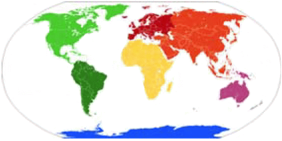 |
|
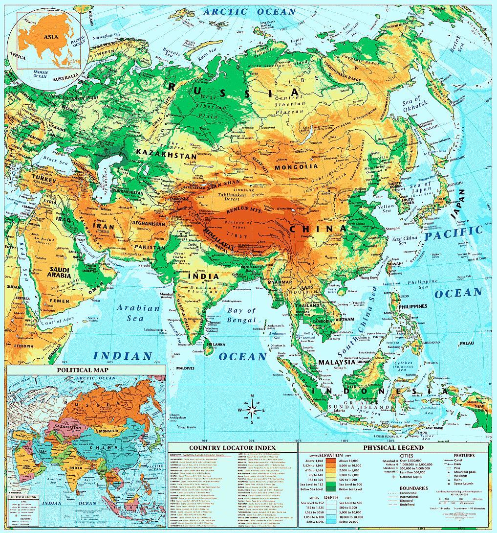
ChinaBeijing Olympic Games: Zhangjiakou (张家口). Shenyang (沈阳). Chongli (崇礼)*. Hebei (河北). Thaiwoo (太舞)*. Wanlong (万龙). Genting (云顶)*. Taizicheng (太子城). (*:ski resort)Wuhan (武漢)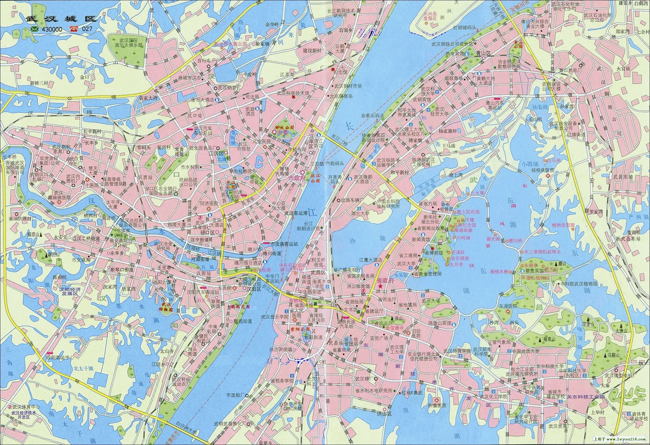 GeoparksLeye-Fengshan Geopark-P.R.China (中国乐山凤山世界地质公园), located in northwestern Guangxi, southwest ChinaShambhala (シャンバラ)Tibetan Buddhism: an ideal Buddhist kingdom described in Kalacatantrareduction of disaster, such as eruptions and tsunami, and seclusion
BangladeshIt was the West Pakistan when I was an elementary school studentCapita = Dhaka (largest in the country) Population (2015) = ca 170 million → density = 1034/km² Geography = largely dominated by the fertile Bengal delta Social problems =
political instability 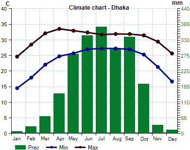
Purbachal New Town Project24.9 km2Sal forest in Purbachal (Sal: Shorea robusta Roth) 122 ha in 2002 → 41 ha in 2014 (Islamic Republic of) PakistanSoutheastern AsiaKhmer Empire or Angkor Empire (802-1218)origin of CambodiaAngkor Wat: 162.6 ha - ditch-enclosed castle Sukhothai dynasty (≈1240-1438)the oldest dynasty established by Tai peoples in the present Thailandstrong buddhist faith - one cause of decline |
Ayutthaya dynasty (1351-1767)Tai peoplessupported by international trade Pagan kingdom, empire or dynastyBamar peoplethe first Burmese kingdom to unify the regions (Myanmar in the present) 1044-1077 Anawrahta, Minsaw, reigned (founder) 1314 demolition Indonesia (インドネシア)Indonesia Natural History National Museum (Museum Nasional Sejarah Alam Indonesia, MUNASAIN) on January 25 2018Biological Indonesia (Hayati Indonesia)Flora: Taxon (Indonesia / World (dunia) × 100, %)a. Spore plant (91,251/1,560,500 = 6 1. Cryptogame (Kriptogam)
- Mushrooms (Jamur) (86,000/1,500,000 = 6) 750,000 (Micro 64,000 identified (diidentifikasi). Macro 16,000)
- Lichens (Lichen) 595/20,000 = 3 b. Seed plant 19,232/251,000 = 8 1. Gymnospermae 120/1,000 = 12 2. Angiospermae 250,000 (identified 19,122, 8 probably 30,000-40,000) Decrease in forests and era of wood industries in IndoensiaIn 19th century, most of Indonesian land, i.e., 193.7 million ha was covered by forests (MacKinnon 1997)In 1950, 163 million ha (84%) of Indonesian land was still covered by primary and secondary forests; tea, coffee, and rubber plantations (Indonesia Forest Agency 1950)
Deforestation since 1970 (million ha/year)
Collapse of Plywood Wood Industries since 1998 In the early 20th century, forest area was estimated 98 million ha (Wasson & Applegate 2000) Era of oil palm industries since 2005 Imaginary lines underlying bioregion sharing in IndonesiaGaris Imajiner yang Mendasari Pembagian Bioregion di Indonesia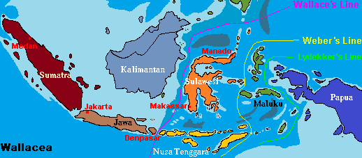
→ vertical distribution of vegetation on Mount Jayawijaya IPB, January 23/24 2018 Hokkaido University Liaison Office in Indonesia: Grand opening studium generale and workshopObjectives of this workshop
|
Oceania = Melanesia + Micronesia + Polynesia + Australasia

Micronesiaa subregion of Oceania (composed of thousands of small islands in the western Pacific Ocean)Mariana Islandsa part of Izu-Bonin-Mariana Arc (IBM Arc)Chamorro, a micronesian native, lived - 17C forced relocation to Guam 9C-17C Latte stone (Taga stone) - use unknown Caroline Islands1527 exploration by Diego da Rocha (Portugal) - later, Spanish territory1899 sold to Germany - until first World War 1914 Japanese territory - 1920 territory mandated by Japan After WII: trust territory of the Pacific Islands
1986 Federated States of Micronesia
stoen walls and megalith consisting of a series of small artificial islands linked by a network of canals in a lagoon enclosed by mangroves Melanesiaa subregion of Oceania (from New Guinea island in the southwestern Pacific Ocean to the Arafura Sea, and eastward to Tonga)Polynesiaa subregion of Oceania, made up of more than 1000 islands scattered over the central and southern Pacific Ocean |
Easter Island (Isla de Pascua, Rapa Nui)formed by the eruptions of underwater volcano
The last eruption recorded in 100 Kya Moai: monolithic human figures carved by the Rapa Nui people on Easter Island between 1250 and 1500 → deforestation TuvaluSamoa (サモア)Independent State of Samoa (1962) |W171°| American Samoa (territory)Independent State of Samoa, often called as Samoa Capital city: Apia on Upolu Island 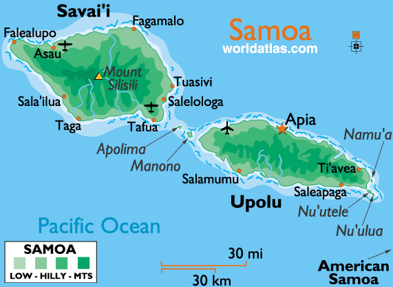 Volcanoes: Savai'i and Upolu 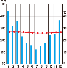 Fig. Monthly precipitation and temperature in Apia Tonga |
|
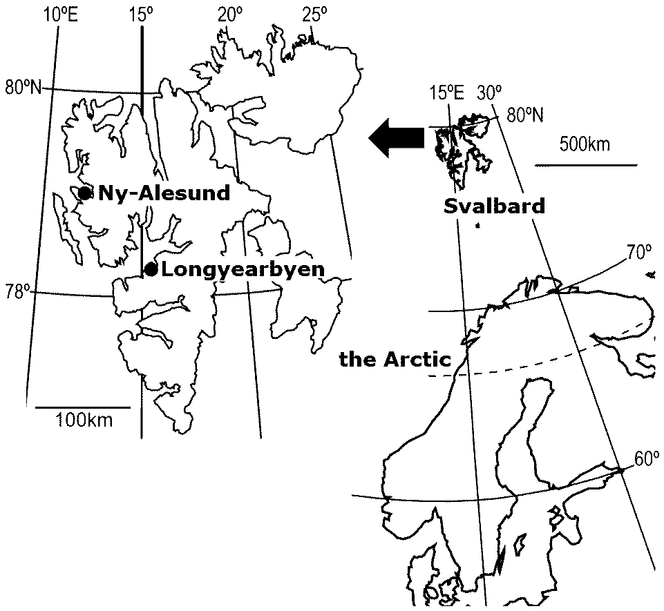
Plants in Svalbard Sanionia uncinata (カギハイゴケ) Cetrariella delisei (トゲエイランタイ) Salix polaris (キョクチヤナギ) Saxifraga oppositifolia (ムラサキユキノシタ) Dryas octopetala (チョウノスケソウ) SpitsbergenThe largest island in Svalbard Islands (N76-81°,)1926 Amundsen. Norge Roald 1926 Byrd, Richard E. NetherlandsDef. Polder (ポルダー): ow-lying tract of land forming an artificial hydrological entity, enclosed by embankments (dikes)Before the Second World War, 30% of land was polder
Land reclaimed from a body of water, such as a lake or the seabed saline water conversion → sowing reed seeds → mesic succession (= terrestrialization) → prescribed fire → cropland/forest/building |
MountainsAlaskan RangeCoast Ranges___________________________Laurentian Plateau __Cascade Range__Rocky Mountains Sierra Nevada Range_______________Appalachian Mountains __________Sierra Madre Range Alaska (アラスカ)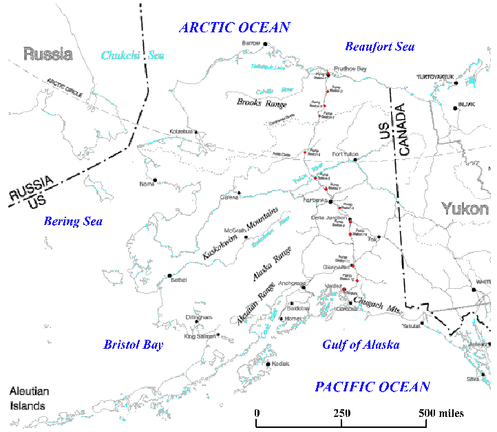
• wildfire (森林火災) NomeFRONT STREET: Front Street has been the business district of Nome since the Gold Rush. In 1900, the street was lined with businesses, bars and bunkhouses. A miner could buy anything, from French lingerie to a hot bath. |
Cascade Range (Cascades, カスケード)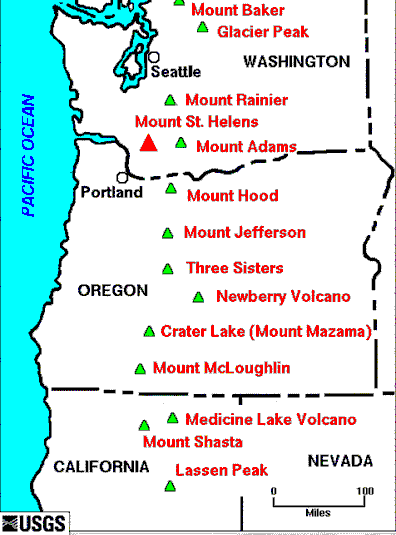
[ plant species | vertical distribution | forest | wetland ] Major Cascade Range volcanoes
Mount St. Helens (セントへレンズ山) Portland, OregonDowntown: ESA meeting in 2017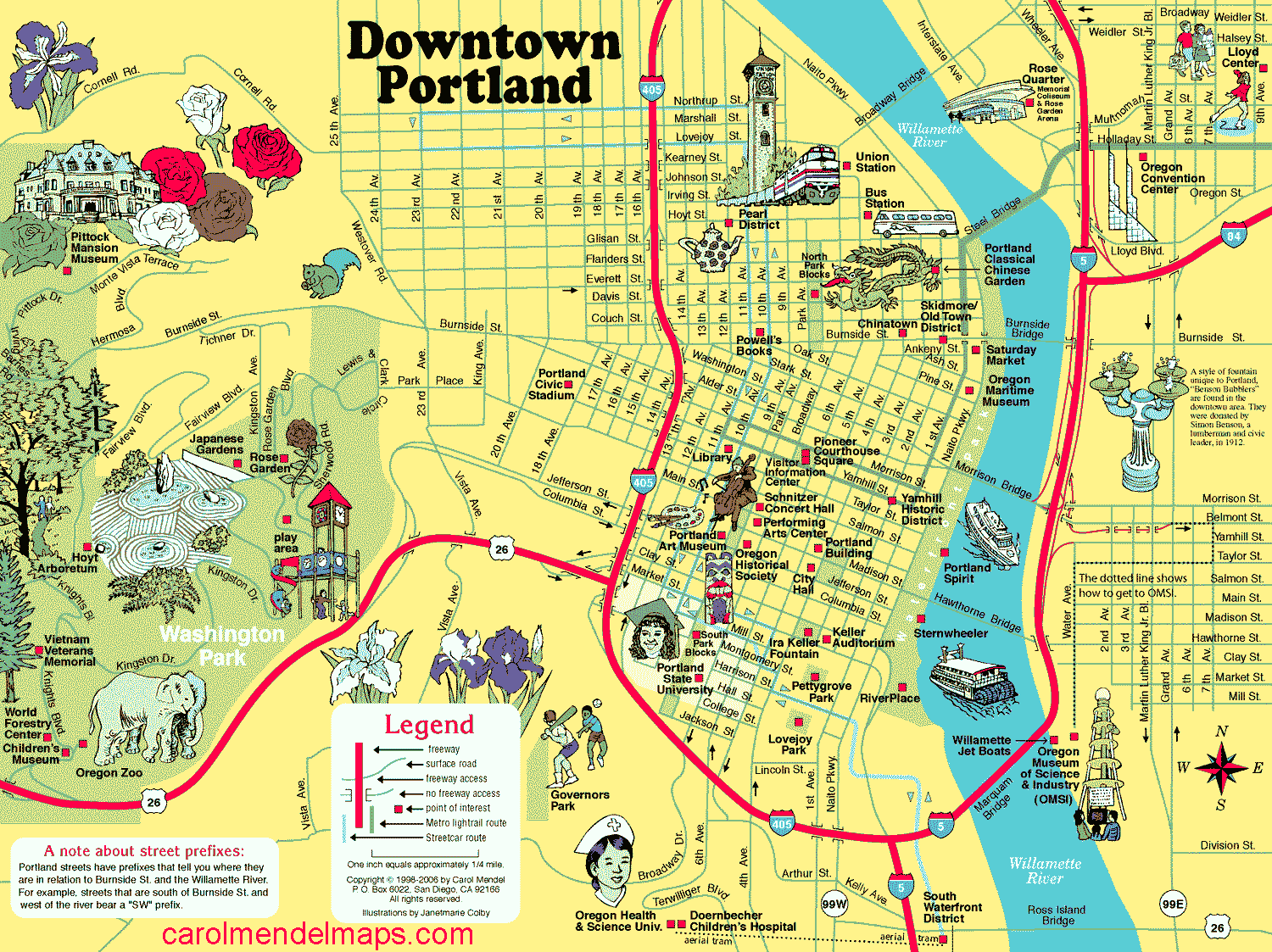
|
Guyana (ガイアナ)= Co-operative Republic of Guyana (Capital: Georgetown)Official languages: English (only this country in South America)
1831 British colony, called British Guiana Galapagos Islands (ガラパゴス諸島)= Islas Galápagos (Spanish, galápago = turtle)archipelago of volcanic islands in the Eastern Pacific around the Equator 900 km west of the mainland of South America officially the Galápagos Province of the Republic of Ecuador 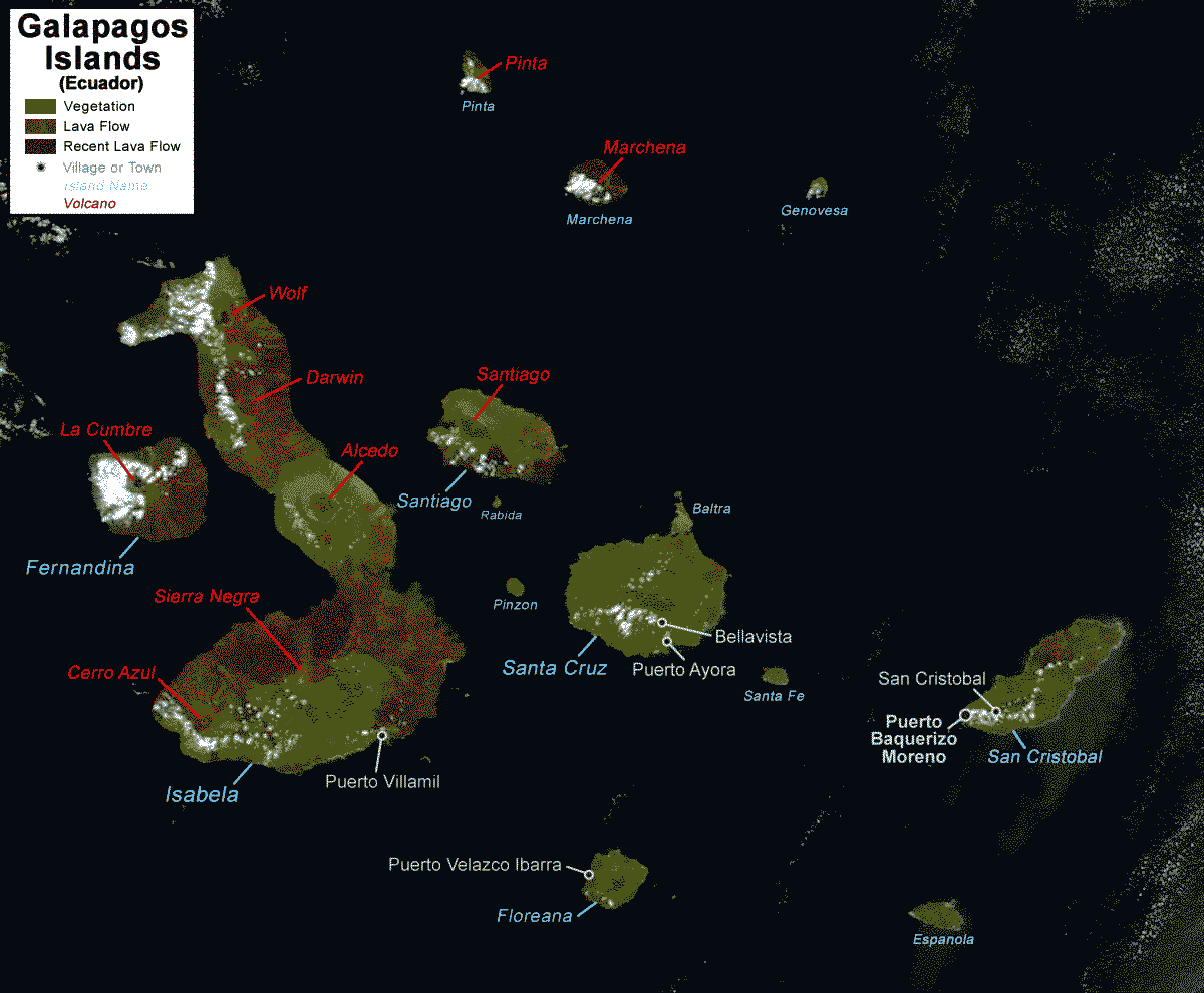 Fig. Galapagos Islands (Equador) History1535 Fray Tomás de Berlanga: firstly discovered
the Bishop of Panama - distress and reached Galapagos The islands named Las Islas Encantadas (enchanted or bewitched islands) 1570 Abraham Ortelius 1527-1598 (Flemish cartographer)draw world atlas - the islands named Insulae de los de Galapagos whale hunt: pirate was popular before whale hunt1793 Captain Colnett, James: Ship Rattler, whale hunt reported a post in Post Office Bay on Floreana Island 1807 Watkins, Patrick (Irish sailor) - first settlementmarooned on Floreana - survived by available drinking water, hunting, growing vegetables and trading with visiting whalers exploitation started1832 sovereignty of Galápagos claimed by Ecuador
formal nomenclature = Archipiélago de Colón
overhunting Ex. giant tortoises
1835 (Darwin visited) 300 people (1832 80) 1924 Beebe, William 1877-1962: Galápagos: World's end accompanied Harrison Williams Galapagos expedition (1923) Heyerdahl, Thor 1914-2002, adventurer and ethnographer
1947 Kon-Tiki expedition - drifted 8000 km |
≈ 1975: constrction of road network 2000 Eibl-Eibesfeldt, Irenäus 1928-2018 Galapagos. Die Arche Noah im Pazifik Geography (地理)Miocene (23.03-5.332 mya): volcanoes on the ocean floorTable. Recent eruption history
1150 Ecuador
1991 Marchena Island
2018 Sierra Negra Biology (生物)1825 Douglas, David & Scouler, John: collected 23 plant specimens1825 McRae, James: collected 41 specimens from Isabela Island 1829 Cuming, Hugh 1791-1865: collected 9 specimens 1835 Beagle: arrived - Darwin 1905- expedition rush 1957 Bowman and Eibl-Eibesfeldt Team: a 4-month expedition
supported by the IUCN and UNESCO Seed plants: 500 species in 206 genera Asteraceae: 56 secies in 22 genera - 42 endemic species Table 1. Geographical relationships of the indigenous vascular plants of the Galapagos Islands (Porter 1976)
Endemic
Neo-
Pan-
Andean
M/CA
SA
Total Neo-: Neogropical. Pan-: Pantropical. M/CA: Mexico and Central America. SA: South America Table 2. Original introductions that have resulted in the present vascular plant flora of the Galapagos Islands
Introduced
Birds
Man
Wind
Drift*
Total Scalesia Arn. (スカレシア), Asteraceaelifeform: soft, pithy wooded tree - unusual for Asteraceae
shrubs: arid lowland ↔ trees: mesic highland an ancestral species → 12 shrubs and 3 trees in response to moisture
= the Darwin's finches of the plant world - herbaceous characteristics Other endemic Asteraceous genera: 3 genera
Darwiniothamnus Harling: D. alternifolius Lawesson et Adsersen, D. lancifolius (Hook. f.) Harling, D. tenuifolius (Hook. f.) Harling Rainfall: seasonal and irregular, averaging 240-1000 mm/yr, with a pronounced dry season lasting 6-11 months Temperature: high, often exceeding 30°C during the dry seasonBiome: tropical dry forest, (xeric shrubland or thorn forest) Vegetation characteristics:
Deep root systems, e.g., Caesalpinia ferrea, to access groundwater |
|
The place of origin of humans and the Hominidae clade (great apes) Area: 30,370,000 km2 Language: 1250–3000 native languages Region: North + West + Central + East + Southern Africa African independence historyEthiopia (formerly Abyssinia) 1941 Abyssinian campaign in World War II→ socialization (社会主義化) 1945 Pan-African CongressGhana 1957 formerly the Gold Coast, independence from UK Congo (Zaire 1971-1997) 1960 from Belgium 1977, 1978 Shaba Province conflict - genocide Côte d'Ivoire 1960 from FranceNigeria 1960 from UK 1966(twice), 1975, 1976, 1983: military coup (軍事クーデータ) Tanzania 1961 as Tanganyika from UK → socializationKenya 1963 from UK: Nairobi: large slums 1982 Black Sunday (military coup - failed) Gambia 1965 from UKZimbabwe 1965 unilateral declaration by Southern Rhodesia 1980 recognized independence from UK as Zimbabwe Uganda 1962 self-government granted → independence from UKAmin (1971-1979, president) - dictatorship (独裁) Mozambique 1975 from Portugal → socializationAngola 1975 from Portugal → socialization 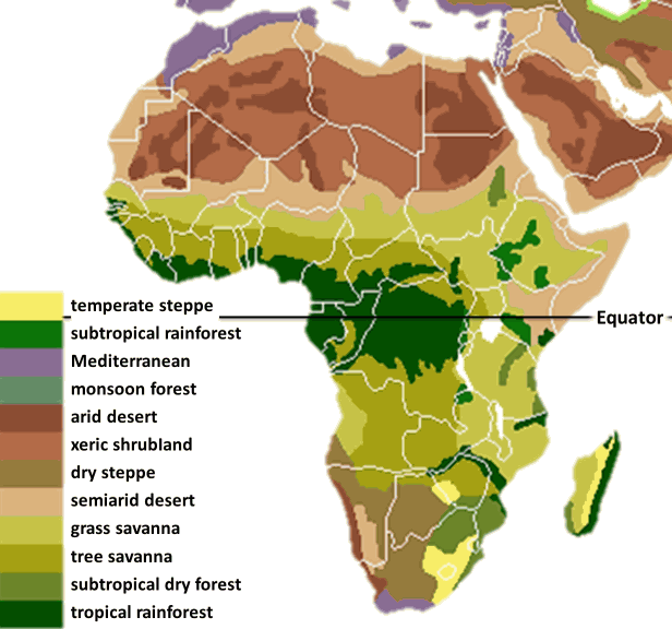
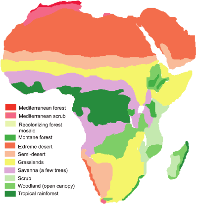
Fig. Present vegetation____________Fig. Potential present vegetation These maps are similar with the map of Köppen climate classification |
Deforestation + soil degradation(The Republic of) South Africa (南アフリカ)1867 discovered diamond1886 discovered gold black peaple = low-wage, unskilled labor 1899-1902 Second Boer Wars1910 Union of South Africa Apartheid (アパルトヘイト)Smuts, Jan Christiaan (1870-1950, Cape Cology, present South Africa)
politician, soldier and philosopher
not a direct architect of apartheid, but his political legacy and racial views helped lay the groundwork for its later institutionalization
The rights of the majority black inhabitants were severely restricted and they were segregated from the white minority in almost every aspect of life, including education, healthcare and employment enforced strict residential and social separation Soweto (south western township): thsee problems still remain today
originally established by the government, as a residential area for Black South Africans under apartheid → 1976 the Soweto Uprising: students protested against Afrikaans being imposed as the medium of instruction Ghana Empire (Ghanata or Wagadou)AD1C-AD3C: established
control of the trans-saharan gold trade 1235 submitted to the Mali Empire 1874-1957 British colony |
[ Western Australia | Anthem ]
|
Australasia: a region of Oceania, comprises Australia, New Zealand, neighboring islands in the Pacific Ocean, and sometimes, the island of New Guinea
Tropical rainforest Mediterranean: smoke-induced seed germinaiton |
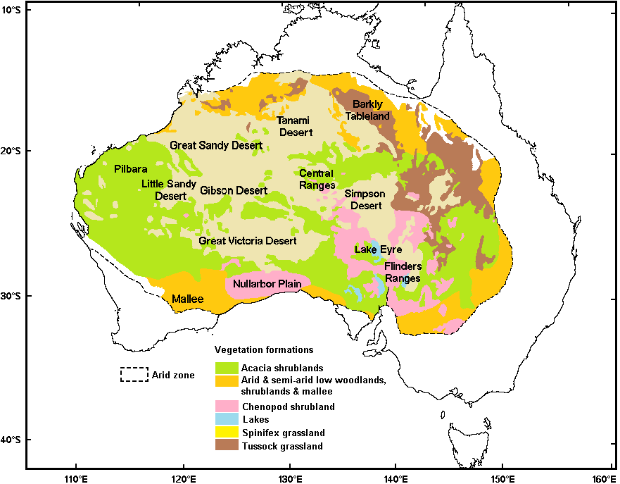 Fig. Vegetation formation (Moore & Perry 1970). Arid zone boundary derived from rainfall and evaporation. Nullabor Plain (ナラボー平原)Etymology: nullus (none)+ abor (tree)20000 km2 (1200 km long from east to west) Annual precipitation < 250 mm |
|
= Arctic + Antarctic Def. Arctic: polar region located at the northernmost part of Earth
Arctic Ocean and the adjacent seas
= North Slope Borough, Northwest Arctic Borough, Nome Census Area, and is sometimes taken to include parts of the Yukon-Koyukuk Census Area Subpolar regionaround latitudes 60° to 65° N/S of the Equator |
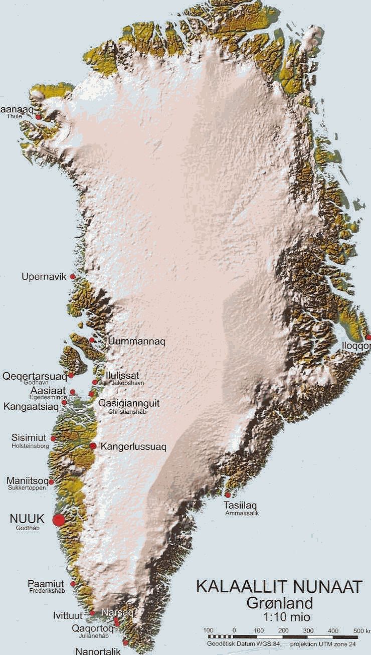
Greenland (グリーンランド)Kalaallit Nunaat (island of human, Greenlandic) - Dominion (自治領) of DenmarkEGIG, Expedition Glaciologique Internationale au Groenland (International Glaciological Greenland Expedition, グリーンランド国際氷河学遠征) |