(Upload on July 17 2021) [ 日本語 | English ]
Mount Usu / Sarobetsu post-mined peatland
From left: Crater basin in 1986 and 2006. Cottongrass / Daylily
HOME > Lecture catalog / Research summary > Glossary > Japan > Hokkaido
|
Location: N41°24'-45°31', E139°45'-145°50' Area: 83,453.57 km2 (Tokyo Metropolis 2191 km2) - 22% of Japan 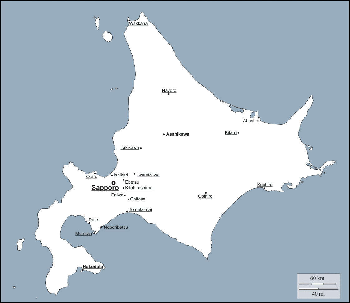
ClimateCool temperate zoneLow tempeature, lower precipitation |
GeographyMany active volcanoesWetlands, such as Sarobetsu Classification of regions, representative (地域区分)
Tree: Ezomatsu (エゾマツ, Picea jezoensis) Bird: Tancho (タンチョウ, Grus japonensis) • coalfield (炭鉱) • mammals(哺乳類) • skislopes (スキー場) • soil (土壌) • vertical distribution of vegetation (植生垂直分布)
Mount Shiribetsu (尻別岳) 1107.4 m |
Shibetsu wetland or mire (標津湿原)National Natural MonumentIchani Karikariusu Site - Group of Shibetsu National Historic SitesShiretokoBear CountryDon't approachDon't feed! Ministry of the Environment / Hokkaido / Town of Shari Rausu |
Oshin-Koshin FallsThe name Oshinkoshin originates from the Ainu language, meaning “a place where many Ezo spruce grow”. As the waterfall consists of two separate flows, it is also nicknamed “Soubi no Taki” meaning “beautiful forked waterfalls”. Oshinkoshin Falls were selected as one of Japan’s 100 beautiful waterfalls in 1990. |
Wakkanai (稚内)The origin of WakkanaiIn 1633, during the Edo period (Kan’ei year 10), the first Sakoku Edict was issued. Under this edict, merchants were banned from direct commerce with the Ainu people, and the only port of entry into Ezo (the land now known as Hokkaido) was through the district of Matsumae. During this period, the Soya area was opened as a territory under the control of Matsumae.By the late 18th century, Russia had appeared seeking trade within Ezo. As a countermeasure, the Soya area was secured by members of the Tsugaru and Aizu clans. Famous samurai such as Ihara Yaroku, Mogami Tokunai, Matsuda Denjuro, and Mamiya Rinzo also came to Soya by decree of the shogunate. |
In July of 1879, the 12th year of the Meiji era, a city office was placed in what was then known as the town of Soya. This is considered the beginning of Wakkanai. In 1990 (Meiji year 33), Wakkanai officially split off from the Soya township, and in 1955 (Showa year 30) the two districts combined to become Wakkanai City as we know it today. Even no in Soya, the remnants of the Soya Gokokuji Temple, Soya Itsukushima Shrine, and the grave sites of Soya’s old samurai remain as important symbols of Wakkanai’s history. Wakkanai Board of Education |
|
Characteristics: Horoman peridotite (幌満橄欖岩) → many endemic and/or endangered species (alpine plants) 2008 Japanese Geopark 2015 Global Geopark Erman's birches above dwarf stone pines:vertical distribution turned upside-downWhen you climb Mt. Apoi, from around the seventh stage, you will reach the forest limit and gain views of the surroundings. However, the summit is in the middle of a forest of Erman's birch trees, and does not offer any view. This is another of Mt. Apoi's riddles. Normally, with increasing altitude, mountain vegetation changes from broadleaf to coniferous forest zones and then to an Erman's birch forest zone. The end of this zone is also the forest limit, and above the Erman's birch zone, there is a dwarf stone pine zone. On Mt. Apoi, however, the vertical distribution of the vegetation is upside-down: the Erman's birch forest zone is above he dwarf stone pine zone.Alternate Layers of Gabbro and PeridoliteSixth to seventh stages Mt. Apoi reaches the forest line around here. Beyond this line is the dwarf pine zone. The horizontal layers beyond the sign consist of alternating rugged gabbro and receding brown peridotite. The Horoman peridotite complex from which Mt. Apoi is formed has a massive layered structure made up of varied types of peridotite and smaller amounts of mafic rock.Mt. Apoi GEOPARK Why do endemic alpine plants bloom on a low-altitude mountain?Alpine plants on a low-altitude mountains and an abundance of flowers that bloom only here. These are the two greatest attractions and the most intriguing features of Mt. Apoi. There are believed to be three reasons for two mysterious phenomena. |
|
|
Climate: humid continental climate (Dfa) Symbols: Tree = lilac (Convallaria majalis L.) Flower: lily of the valley (Syringa vulgaris L.) Bird: common cuckoo FloraConspicuous to exotic species (Tsuyuzaki et al. 2011)Seven Horomui Herbs (ほろむい七草)Horomui (ホロムイ): the southwestern part of Iwamizawa
|
Geography (地形) Headquarters for the Shinkotoni Soldier Village新琴似屯田兵中隊本部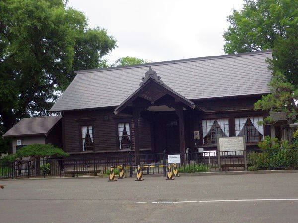 This building was constructed as the headquarters for the Shinkotoni Soldier Village (the Third Farm-Soldier Company of the First Battalion), formed in 1887 as one of the bases for the development of Hokkaido by farm-solders. The shape of the building is simple, possessing a noble appearance. Characteristics of western-style timber construction, which was popular at that time, are found in the entrance area and around windows, etc. The City of Sapporo designated the building as a cultural property on April 20, 1974, and now preserves and manages it.
|
[Moiwa skislope, landscape on skislopes]
|
South Ward, Sapporo (43°01'05''N, 141°19'31.9''E, 531 m a.s.l.)
1960 Ski liftts on moiwa skislope Mount Moiwa stands at 531 m above sea level, and is called “Inkaruspe” in the Ainu language. Mount Moiwa is not only a lookout spot for salmon swimming upstreams, but is also honored as a sacred mountain. Every year, Ainu people and citizen volunteers perform a traditional ceremony praying Kamuy-nomi here.Takeshiro Matsuura, an explorer from the late Edo period, described Mount Moiwa in his journal Shiribeshi Nisshi as the mountain of the Ainu people’s beloved deity. In addition to the panoramic view of Sapporo City and the Ishikari Plains, the mountain is rich in greenery, boasting over 70 unique types of trees, including the Japanese Judas (ranko*), elm (cikisani), magnolia (opke-ni), and white birch trees (tatni). On March 3rd, 1921, Mount Moiwa Primeval Forest was designated a Natural Monument of extraordinary academic value. |
*: the terms in parentheses are the Ainu words for these trees
September 2018 City of Sapporo Characteristicsprimeval forest (nickname) → non-primeval forest, in a precise senseTakeshiro Matsuura "The Diary in Shiribeshi" Feb. 11 1858 (lunar calendar)
"... a small mountain covered by needle-leaved trees on the west bank, that is Mount Moiwa ..." |
|
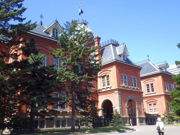
The Former Hokkaido Government Office BuildingThe former Hokkaido Government office building, nicknamed "Akarenga" (lit. Red Brick), was constructed in 1888 as a base for the administration of Hokkaido. Designed by Hokkaido Government technical officials, this American neo-baroque style structure was built entirely from local materials. It was unique in Japan being one of the largest and tallest buildings of the time. The structure, although later being destroyed by fire, was designated as an important cultural property in March 1969.Nopporo Forest Park (野幌森林公園)2503 ha designated a prefectural natural park in 1968110, 400 and 200 woody, herbaceous and fungal species, respectively Tree regeneration is characterized by nurse or fallen logs |
Hokkaido Prefectural Natural Park Nopporo Forest Park Map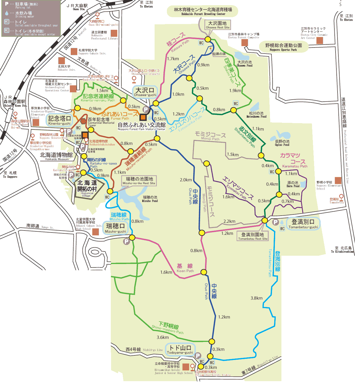 Osawa Reservoir Loop Walk |
We need to consider the history and culture of Ainu when we talk about HokkaidoAynu=itak = Ainu language (Ainuic)Three major dialects in pre-1945 (*: extinct)
Sakhalin* GrammarSOV (subject - object - verb)uses postpositions rather than prepositions |
Pet, Nay: a river Sarobetsu (サロベツ): sar-o-pet サラオペッ (reed swamp·present·river) |
Ainu plant nomenclature (アイヌ植物命名法)Note: many dialects with temporal changeni (tree)ci-kisa-ni: Japanese elm (Ulmus davidiana)eha, aha: Chinese hog-peanut (Amphicarpaea bracteata) pittok: common cow parsnip (Heracleum dulce) pukusa-kina: (Anemone flaccida) paskur-mun (crow + grass): (Apocynum venetum) kito, pukusa: victory onion (Allium victorialis) |
Actinidia polygama (マタタビ) matatampu (マタタンプ): mata (winter) + tampu tampu (turtle shell = gall or souvenir) |